Search the Community
Showing results for tags 'terrain'.
Found 228 results
-
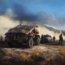
Buldozer Tools by Lappihuan This is a successor to the Improved editor.sqs I’m pretty sure most of you know the following scenarios: “You work for several hours in Buldozer, the rain that is dropping since the last 20 mins is already annoying but the productivity and creativity is on fire. It keeps getting darker and darker and you think that it’s time to restart buldozer but you quickly want to finish the composition you are working on. BOOM! Out of nowhere TB crashes and your adrenalin rushes through the whole body, you didn’t save the project for the last 4 hours!!!†Result: things like this can throw your motivation off for several weeks. “While working on a town, you feel like there is a road missing or would like to move an existing one to fit your object placement better.†Result: you need to restart Buldozer every time you change your roads.shp which is a waste of time! “Players report that AI can’t properly use the awesome bridge you placed on the map, and you can’t figure out why they won’t use it.†Result: you spent many hours to tweak the road and bridge model with a eventual success or use a hacky solution like place an invisible road below the bridge. I hope to eliminate or at least reduce most of the above issues with the Buldozer Tools. Features: Reload roadsDefault key “1†Reset weather and timeDefault key “2†Toggle road diagnosticDefault key “3†Be aware, it can cause Buldozer to crash! DebugDefault key “4†execute the debug.sqf while buldozer is running (helps R&D) NVG and IR modeDefault key “N†Help DialogDefault key “0†Save notificationCustomaisable time in userconfig.sqf While the list is still quite small, I feel like it already has a big impact on the workflow in Buldozer. Installation For the sake of easiness I provide a scripts folder with everything needed in there. Drop the script folder into your P drive so it has the structure: P:\scripts\initBuldozer.sqf You can customize everything in there, but the config.sqf is the most important part for you. If something is unclear / could be made easier, let me know. IMPORTANT: delete or rename your current editor.sqs, so it won't conflict with this. Download Link Feel free to contact me on Skype/discord or here about suggestions, bugs or whatever. I hope you guys enjoy! Thanks to Pennyworth for the help!
- 20 replies
-
- 10
-

-
- initBuldozer.sqf
- editor.sqs
- (and 4 more)
-
Hello All! It has been a while since I have posted on the forums! (Personal Life and all that jazz) I have been a member of the community since OFP however, I didn't migrate my usernames and it seems it has all been lost in translation. My original usernames probably included something similar to OChristie etc! ;) Quick Background: OFP, ArmA 1/2/3, VBS 1/2/3. I make terrains and love it! Lampedusa Challenge The best terrain, mission and unit content pack wins! Summary The community that exists for any large game title always manages to bring a new dynamic to its respective platform. With the ease of modification to the ArmA platform since its conception, the possibilities have truly been endless. Because of all of this, I am very interested to see just how far we can take this little project. Lampedusa Island is here. I would do this myself however I don't feel that I have the skill in A3 terrain development and I love the power that the community have! Structure This challenge can be completed as an individual or as a team. The Challenge To create the best or most interesting terrain of Lampedusa, Italy combined with an in depth, diverse and fun mission to explore it. (Think CTI, COOP, Domination). If you want to create a content pack then feel free! Competition Rules You will have no more than 3 months to complete the challenge and all entries MUST be submitted as a reply to the main BI Forums thread by the 1st April 2017. Most importantly have fun! Tools You are able to use any GIS / Terrain / Mission tools that BI authorise the community to use. Data The starter pack contains Imagery, Elevation and Vector data which should point you in the right direction. You can download the data here: LampedusaChallenge.rar (via Google Drive ~275mb) Testing You are welcome to publicly test your Terrains / Missions on the A3 servers. Good luck. P.S. This thread will grow, please feel free to ask questions and I will add any key information to the thread.
-
Hi, we currently working on a new map called Taunus and we want to show you some progress regularly within this thread. The map will be powered by X-Cam of course and we will invest hundreds of hours, during many MP sessions, in order to finish this map ... asap. Please don't ask about any "release date" because we have only recently started ;) So far 4 people are working on this map: MemphisBelle (MIA) Hotzenplotz Chaser Silola Map size is 20480x20480 m Grid size is 4096 cells Cell size is 5 m If you want to see the whole "first Taunus album", then please follow this link: http://imgur.com/a/7Cuud Silola
- 856 replies
-
- 47
-
-
Sorry if it's mentioned elswhere, I don't read the forums as often as I used to. Anyway, I appears that during this year's Blender Conference Miroslav Horvath from BIS (Bohemia Interactive Simulations) again had a talk about the tools he's continuously developing for 8 years. I think it's a good place to post it, since the tools are a Blender addon for improvements of terrain editing workflow for Real Virtuality engine (Arma, VBS, ToH, DayZ...). There are some interesting insights on how Take on Helicopters terrain was created, or what does VBS streams simulation that could be seen some time ago in some trailers looks like from behind the scenes. My original topic from several years ago concerning the same tools but in Arma 2 version: Well, "eight years in development, and still not released" :)
- 4 replies
-
- 2
-
-
- blender terrain tools
- horvath
- (and 1 more)
-

Seems the IA's spot distance can see behind terrain, hills.
Boss-Starstreams posted a topic in ARMA 3 - GENERAL
There are too many things going on with the realism in A3 with regard to the AI's ability to know someone is there even when they have cover. The 3den Enhanced helps control the spot distance, but I don't think the mountains, and terrain is actually blocking the radial spot awareness of the AI. Here are a few examples: A tank comes over a hillside and wipes me out every time I hit replay, even though I'm hidden further into the woods while my 12 guys are out in the open. even if I move to new positions before the tanks gets over the hill on my side, It's as though the AI is programmed to target the player more often then the enemy, ...while my guys were out in the open.A tank comes over the hill and wipes out about 10 guys in a matter of 3 seconds, even though the guys are all spaced out at distances from each other of about 30 to 50 feet, and they were commanded to take cover before hand. How in the world would a tank know where everyone is that quick? My friend is an Captain officer in the Army, He's says it's BS. It would take the tank some time to aim at everyone. I can change this behavior with the 3den Enhanced AI settings, but why is the setting so jacked up by default.I'm in prone position sneaking up on some guys in front of me who are about 100ft behind the hill I'm crawling up: about a second before I can see them through the weeds I'm already being shot at and killed by the infantry on foot. It's as though the radial awareness of the AI is NOT being blocked by terrain or even trees. Last point. I realize that the "tanks" and even the infantry have heat sensor abilities, but then wouldn't the other army have heat deflector outfits to help a little? And how can they detect heat when your behind a hill? And it's not like every squad or platoon has that ability at all times. Either way, even if they knew I was there as soon as my head peaked over the hill, there is no way someone can aim and kill me every time on their first shot from 100 feet away while I'm laying down. Unless it's just luck. And the AI seems to have a LOT of luck in A3. The question here is: is the spot distance blocked by terrain? Hills, Mountains? ... Or is it NOT? -
Uk Maps Pack! Firstly welcome and thank you for taking the time to read my post. A few months ago I learnt to make maps for Arma 3. After reaching a stage I felt I would be able to give it a shot, I made several small test maps to have a look at the functionality of Terrain Builder. I have now begun making my first official map for Arma 3, it will be a UK based map, as stated in the topic title. It is based on a small Island called Fair Isle (See Here For Location) I will try to be recreating the Island as accurately as possible, this may be difficult due to the cliffs that surround its cost line & the angle at which the cost lines drastically changes but I will give it my best shot! I will be creating custom buildings for this Island as well, this will increase the immersion and benefit missions scenario. But this will be a secondary aim as I want to get the map created and A3 buildings in as place holders to start. Also every map will have a winter variant so there will be a large variety of maps and seasons. For Details about the map and its towns, airstrips and layout see the image below. Map Screenshots Below is an album I have created that will be continuously updated as I add more locations and features. It currently includes one map location in early development, general screenshots and some building models in early development. http://imgur.com/a/bCsRt The terrain will take priority over the models, the map will hopefully be released for Christmas in working order to allow people to give feed back, any issues found with the map will be fixed by next release in February next year. Please be aware that I am the sole developer on this pack so it will take time to finish but i will be working as fast as possible with the intention of the best quality possible. Please leave any comments that you have here I will try to respond as quickly as possible!
-

Lighting Help Needed in Config.cpp (Terrains)
npmproductions13 posted a topic in ARMA 3 - ADDONS - CONFIGS & SCRIPTING
Hi all i was just wondering if it would be possible for someone to help me with my terrain. First off i used Stratis's config.cpp as a template and changed it suitable to my needs for my island. This means i used Stratis's lighting and my terrain is supposed to be dark and somewhat gloomy, but it is bright like a Greek island, would it be possible to ask someones advice and what lines of code in the config i could change to achieve this effect ? -
This terrain (as some will know) comes from the world of A Song of Ice & Fire or more commonly known as Game of Thrones. It is the entire continent of Westeros (plus the Stepstones). I have been wanting to start a new terrain project and decided on going with this. I think it will be a great terrain for Arma 3 because besides its GoT connection, it offers various biomes and topography. It will also give me a reason to build a bunch of castles on the map :P. I am working out the total size of the map still, but it is looking like it is going to be at least 30km x 30km. Any and all updates I have on the terrain will make their way here.
-
http://i.imgur.com/VRZ07q1.png?1 (183 kB) Gorgona v1.51 by Major Desync Description: Gorgona is a small island located in the Ligurian Sea, 37 km off the west coast of Italy and 35 km north of the island of Capraia. Inhabited and fortified since ancient times, it is now home to an agricultural penal colony, housing 50 prisoners, including those convicted of murder and other violent crimes, as well as Mafiosi. The prisoners work the island's farms, moving freely around the island by day tending crops and livestock, returning to the prison buildings before the evening curfew. In the history of the prison, only one prisoner has escaped, though it is not known if he survived the long swim to the mainland. (Source: Wikipedia) Though based on the real island of Gorgona, this terrain differs somewhat from the actual island. Firstly, the terrain is larger - measuring 3.7 km from north to south, and 2.6 km from east to west (compared to 2.1 km and 1.6 km respectively for the real island). Secondly, the terrain is a lot less steep than the real island. Finally, while the terrain's buildings and roads are based on the real thing, I've taken a lot of liberties to produce some interesting locations for Arma3. Gorgona's size, topography, ground cover, and locations make it perfect for small-unit infantry actions and stealth missions with an emphasis on close-quarter combat. Features: Terrain dimensions: 4.1 km x 4.1km Terrain area: 16.2 sq. km Island dimensions: approx 3.7 km x approx 2.6 km Land area: approx. 6.5 sq km. Heightmap resolution: 4 m/pixel Elevation range: -50 m to 230 m Approx 112,000 objects Hilly, heavily forested terrain, with large olive plantations, and rocky shorelines. 1 main village, with several surrounding farms and compounds. Locations: Prison, junk yard, port, helipad, cemetery, castle, radome installation, military camp, research station. Screengrabs. by 12reviewman. Changelog: Beta v1.0: Released. Beta v1.1: Released. Changelog: Fixed: Keypoint text colour more legible Added: Seabed texture, clutter, rock outcroppings (and a surprise or two). Added: Several small ruins and a small comm compound to wooded areas Added: Secondary entrance to Military camp, plus several new lights to camp and radome. Added: Security fence, gates, new lights to Helipad. Beta v1.2: Released Changelog: Fixed: Smoothed and widened several lethal gullies around the coastline (some are now good clandestine landing spots!). Fixed: Several misplaced objects (tree bin by prison wall, street lamp in town building and others) Fixed: Ground clipping through floor of several buildings. Added: Randomisation of orientation of most trees and bushes to give a more natural look (Thank you to Jakerod and his excellent Atlas terrain tutorial for the pro-tip!) Added: Box pier to harbour area. Added: Pier ladders to square water tanks to allow entry and escape. Added: Break in fence around Helipad. Thanks to Granis, Zonker3210, TokyoIndia, Gav and Jakerod for their feedback for improving the map in this version Beta v1.3 Released Changelog: FIXED: Buildings and markers not appearing on editor and in-game map. FIXED: Crash on exiting Arma 3 after previewing Gorgona in the editor. FIXED: Intermittent issue with activation of environmental lights on first load in to editor or missions. (It seems these issues were due to incompatibilities between new type 60 p3ds introduced in recent Arma 3 updates and BIS Binarize. Beta v1.3 uses type 58 p3ds, which apparently fixes these bugs, but may cause other unforeseen issues.) Thanks to Mikero for his latest Tools update for making this fix possible (and to Twelvecaliber for the tip). Beta v1.4 Released Changelog: ADDED: A few minor cosmetic tweaks to road paths (near Gorgona Scalo) and to the pier at the harbour in Gorgona Scalo. ADDED : Short road segments to gated compounds to allow AI to path through gates better (hopefully). ADDED: any changes to objects introduced in the latest (post-Nexus) version of Mikero's Arma3p. Beta v1.41 (Hotfix for 1.60) Released. Changelog: TWEAKED: Config and surface textures updated to 1.60 standards. This fixes the 1.60 Black Sky bug. ADDED: Some clutter objects around the helipad. REMOVED: Target range objects from the military base. Unfortunately these were crashing MakePbo for some reason. Thanks to james2464 and Makhno for the necessary know-how. v1.50 Released Changelog: Visual optimisation - Making Gorgona Splendid Again. ADDED: Green grass texture plus clutter. ADDED: Three large olive groves on the previously bare slopes on the east side of the island. ADDED: Miscellaneous trees and bushes to blend better with new, darker sat image. ADDED: Functioning or new lights to various locations, inc Gorgona Scalo, the prison and the military base. TWEAKED: Config lighting settings. TWEAKED: Sat image and mask image - there are some changes to the distribution and extent of the different surface textures. TWEAKED: Texture PAAs - to better match updated sat image. Stony PAA swapped for soil PAA. TWEAKED: Clutter on dry grass textures. TWEAKED: All non-concrete roads changed to dirt trails. Thanks to t800a and Cype_Revenge for visual optimisation hints and tips. v1.51 released Changelog: FIXED: Ingame map grid is no longer divided into two large-scale grid squares. Thanks to Makhno for the pro-tip. Known Issues: None currently. Licence: This addon is released under the Arma Public Licence Share Alike (APL-SA) licence Credits & Thanks: CAPTNCAPS (teamproskill) and FSF for their incredibly helpful tutorials. Bushlurker, M!lkman, Jakerod and the many others who offer help and advice in the Arma 3 Terrain forums. Mikero for his invaluable and amazing tools Gav, Sam, and Geks for alpha testing. Contributors to this thread for posting issues and feedback. BIS for making the Arma series in the first place Download: Armaholic Play with Six Steam Workshop
-
Hello evereyone! I googled anything i could think of, there are some similar issues but not really like this. So, i'm working on my first terrain and i exported it for testing the clutter and in the map i noticed something strange http://imgur.com/D89CxRR Then,closely http://imgur.com/NiUtNQt http://imgur.com/AkHxF74 And in Bulldozer http://imgur.com/7fJg4hJ The terrain is 1024x1024 by 10 in ASC format from L3DT. I saw that other users have similar problem but with peninsula terrains, and they solved the problem changing something in the config. How can i solve this? Do i need to go back to the start?
-
Hello ArmA 3 Community. For the last 4 months i've been working on a terrain called "Finland". It's a fictional terrain based off Finland, the country with the 1000 lakes (and a few more). This is not a release but an inside look at what it will turn into when it's finished. Finland is a winter terrain at the size of 10 x 10 km, all of which is playable. Features: (so far) Custom Trees (A2) 1 Big city 2 Airfields, 1 military and 1 civillian Few military outposts and bases scattered across the map. Couple of small and medium sized villages all across the map. Lots of lakes (It's finland after all) Lots of mountains. A big easter egg (physicly big) https://gyazo.com/0249191e61b5cbf357b78846d2c863d1 https://gyazo.com/c77d388d13640de5ab3ae4631ed67068 https://gyazo.com/198fc7a43c1ca300984df17db51049e6 https://gyazo.com/d1740f7c859a897f70cb0bfeac15b699 https://gyazo.com/2c5da9ef2cc25fa8f37cc3d42e8b3032 https://gyazo.com/5c242f4eed67279c1d6f93cb20512368 https://gyazo.com/c15876b640c9985dbd899d1f6f2d8d66 https://gyazo.com/b3528ce3ce716b86e3e68dffbd7fd934 https://gyazo.com/09493ee068d2d42cca6abd874a57fece https://gyazo.com/40824d0d3f10360ac4542824b584145b Planned Features: 1 more big city Few more villages Complete second airfiled Flatter roads and much more. I am happy for any feedback that i can get, positive or negative :) Thanks for reading //Cookies
-

How do I export/import objects from another map project?
obrez posted a topic in ARMA 3 - TERRAIN - (BUILDER)
SOLVED: I didn't think to load the template libraries from the old project before attempting to import the objects via exported .txt file. I got sloppy and disorganized across a bunch of folders and decided to start a fresh, consolidated project in terrain builder for my island and I successfully imported the old terrain, satmap, mask and all that. Everything is there, including the roads. However, I cannot for the life of me figure out how to export and import all the objects. I've tried exporting them but they just go into a "file" file and do not show up as a choice when I go to import them. Anyone know the trick for this one? The terrain is identical, I just need the objects copied over in their correct locations. Thanks for any help on this one! -
Your New Map Looks Great! However, the well known terrain problems are so disheartening. Every player here has seen, and has had to deal with floating rocks, trees, bushes, AI, and Players due to terrain not displaying properly. No setting tweaks fixes this %100. The closest thing we can do is SEVERELY limit our view distance to the point where it is a handicap. Seeing players, objects, or AI through mountains and hills takes away from the game, and is borderline infuriating when you are shooting at something that is really on the other side of the mountain, but you can't tell until you shoot and watch dirt exploding where their body is. Terrain is crucial to a MilSim and just gameplay in general. Can you tell us that you have addressed this!! The screenshots I provided are nowhere close to the worst examples of this problem that EVERY player deals with. If you have better examples guys, post your pics!!!! (In my first picture...these AI were actually on the opposite side of the mountain...)
-

Which terrain for base making/expand?
Luke_z_Brna posted a topic in ARMA 3 - ADDONS & MODS: DISCUSSION
Hi. I'd like to ask you where you want that i have to started making/ expanding bases. You can choose from three options and if you choose "Another" please write which terrain you want. Best provided terrain that is already released and not in the WIP. Thanks EDIT: If you choose one of these three options please write terrain which you want for example European terrain - Chernarus etc. or ME - Zargabad etc. i hope that its clear. Thanks Greets DonbassCZ -

Packing terrain and custom models with pboproject
stoo65 posted a topic in ARMA 3 - BI TOOLS - TROUBLESHOOTING
I have decided to continue with a map project I started a few years ago and had stopped due to the upcoming release of Arma 3 and it's new tools. I have managed to get my map into terrain builder and finally working in game which is great. My problem is that I had started creating some custom bridge models in oxygen and I was able to add them add to my map. These models were very basic just mostly for show with no physical properties and config files etc. I am using pboproject to pack all my terrain files and models into two pbo files one for my map and one for custom models. I can pack the terrain files no problem but when I add my custom models to my map pboproject stops at my models with the following error xxx.p3d needs to be in temp as binarised. pack your models, or copy over a binarised p3d When I use binpbo I can pack the models and they appear in game so I'm not sure if it is my setting in pboproject. I can pack the models using addon builder but I still get the same error when I try to pack my map with pboproject I am not sure if it's the folder structure I have or my pboproject settings. PC Folder structure and Pboproject settings http://imgur.com/a/D1qNG Models from Arma 2 map http://imgur.com/a/SDeEI I'm running out of whiskey trying to sort this out !!!! -
7:27:20 Warning Message: No entry 'bin\config.bin/CfgWorlds/kapolei/Clutter/DefaultClutter.model'. 7:27:20 Warning Message: '/' is not a value 7:27:20 Warning Message: No entry 'bin\config.bin/CfgWorlds/kapolei/Clutter/DefaultClutter.swLighting'. 7:27:20 Warning Message: '/' is not a value 7:27:20 Warning Message: No entry 'bin\config.bin/CfgWorlds/kapolei/Clutter/DefaultClutter.scaleMin'. 7:27:20 Warning Message: '/' is not a value 7:27:20 Warning Message: No entry 'bin\config.bin/CfgWorlds/kapolei/Clutter/DefaultClutter.scaleMax'. 7:27:20 Warning Message: '/' is not a value 7:27:20 Warning Message: No entry 'bin\config.bin/CfgWorlds/kapolei/Clutter/DefaultClutter.affectedByWind'. 7:27:20 Warning Message: '/' is not a value class DefaultClutter; class Grass_Green1: DefaultClutter { model = "arma3map\kapolei\clutter\c_StrGrassGreen_group.p3d"; affectedByWind = 0.6; swLighting = 1; scaleMin = 0.7; scaleMax = 1.0; }; i dont have any errors in pboproject but once i load my map into editor i get the message above
-
Hi ARMA Community, After my first project "Evergreen" was released last week, and getting still good feedback on it, i am happy to show you the first public preview from my new project. As i say, i will release bigger terrains with more quality, this one will be about 64km² more hotspots, sightseeing and complex ground textures. At this point, thanks to: Jona - helping with clutter.cfg NeoArmageddon - for the great MapBuilder Tool i will use for development. If you have any wishes for the new Terrain, plz let me know and share your ideas gretz daSh :)
-

[WIP] Isla de Cabrera / The Goat Island
singlot posted a topic in ARMA 3 - ADDONS & MODS: DISCUSSION
WIP [sorry for my Inglish i use transladator] Cabrera Island is a small island in the Balearic Islands, Spain. I have tried to capture their profile and best field within the constraints that give me the objects. In some cases due to the limitations I have taken some license. This version is in Beta01. Missing many things yet to make and review. cheers [ESUS]SinGloT Some hi-res screens: http://imgur.com/a/lz9aw#0 http://imgur.com/a/8F9ng#0 Video InGame https://youtu.be/tqxUcyQ6fBA https://youtu.be/L1jDPPHaVM4 https://youtu.be/I1hrPd3LWtw ================================================================================ -------------------------------------------------------------------------------- Mapframes Definitions Name: "kab" [current] Easting (m)..............: 200000.000 Northing (m).............: 0.000 Size (m).................: 10240.000 x 10240.000 Terrain grid size (cells): 1024 x 1024 Terrain cell size (m)....: 10.000 Imagery size (px)........: 10240 x 10240 Imagery resolution (m/px): 1.000 Texture layer size (m)...: 20.00 x 20.00 ================================================================================ ================================================================================ Trabajando en el Isla de Cabrera es una pequeña isla situada en las Islas Baleares, España. He intentando plasmar su perfil y su terreno lo mejor posible dentro de las limitaciones que me dan los objetos ya creados. En algunos casos debido a esas limitaciones me he tomado alguna licencia. Esta version esta en Beta01. faltan bastantes cosas aún por colocar y repasar. ================================================================================ Salu2 [ESUS]SinGloT Some hi-res screens: http://imgur.com/a/lz9aw#0 http://imgur.com/a/8F9ng#0 Tutorial Crear Mapas en Arma3 - Español -
With this first entry, we are starting a series of irregular developer diaries, which should give you a glimpse into the problematics of creating Take on Mars. In this developer diary I would like to give you an idea how we proceed during the creation of the realistic locations in Take on Mars. Do not be afraid, it is not rocket science and I am sure that after reading this series of articles you will have an idea on how to create locations of your own, using the integrated Workbench suite shipped with the game. What we do, is that we first create a "Supertexture" – a high resolution image of the landscape which is mapped on to the in-game terrain. As a source for this Supertexture, we use the publicly available satellite data provided by NASA. These images are accessible under the "Public Domain" license, which means that anyone can grab these images of Mars acquired by the HiRISE satellite and use them in their products. www.uahirise.org, source for satellite data acquired by NASA. Courtesy of NASA/JPL/University of Arizona For this example, I have selected the satellite images from the North pole which I am currently working on. HiRISE lets you download the black and white satellite images in an extreme resolution of 32046×42431 pixels. When imported into Photoshop, the final file can take up to 4GB of data; that is the situation where a PC with a large amount of RAM comes in handy. Such a huge image provides a resolution of ~4 pixels per square meter. For both polar caps (south and north) we decided to create two 2×2 km locations. This means that the final resolution of the Super texture for this location will be 8192 pixels. These 2×2 km represent the playable area, but won't look all that good if the terrain is suddenly cut-off at the edges. Therefore it is necessary to create an illusion of the much wider terrain, which is achieved by making a fake surrounding terrain via model. To ensure good visibility, we need to take data from an area of at least 5×5 km, which makes up an image of total 20480×20480 pixels. The satellite image ready to be cropped, the white rectangle represents the playable area (2x2 km) The final 20480×20480 px. image will serve as a source for creating the texture for the fake surround terrain and also for the 8048×8048 Supertexture used in the location itself. Because such huge images are very cumbersome to work with, it is better to first create a low resolution re-color prototype and test it in game. Supertexture prototype in game editor, mapped on flat terrain Sometimes NASA also provides terrain height data with their satellite pictures. Unfortunately in this case there weren't any height data available for this location, thus it was necessary to sculpt the terrain by hand, but that will have to wait until the next developer diary!
-
ISLA DUALA FOR ARMA 2 Version: v1.97 First Release: December 30th, 2009 Previous Release 1.95: June 12th, 2011 Current Release 1.97: October 24, 2012 Complete readme file can be found here: http://www.icebreakr.info/readme_duala.txt Minimalaco's Introduction Video: d26soJ1jkD4 Changelog v1.97 =========== town Bolabongo upgraded, new Dendala District added final brg_africa v1.24 fixed grid offset for artillery smoothed out road near Numbo and Ursana new clearing E of Mawimbela near river pass new factory and a farm near Kirabo further improvements to satmap upgraded the Pumado Armybase Canto armybase slight update aircraft now taxi correctly at Kinsella Intl. runway upgraded landing system lights at Kinsella Intl. & Aeroporto Molatia Intl. runways on W and E sides activated oil pumps presidental palace added to Bolabongo outskirts added three Molatian forts, used for defense of Bolabongo added new warehouses for Molatian army massive redesign of beaches added more detail and cover spots suck as rock formations several smaller bugfixes Units changes: vehicle classes for Viggens and AS-350 Squirrels now use standard Air class unarmed AS350 Squirrel versions dont have a graphics glitch anymore 7x FFAR Launcher on AS350 has a proper display name replaced Leopard 1A5 crew from Rifleman to Crewman Leopard sound distance fixed, new realistic engine sounds removed zetaborn faction tweaked Mig-21 handling / control sensitivity replaced Mig-21 sounds with improved real recordings Mig-21's UB32Launcher now has correct 57mm rockets, half-load in each launcher removed old texture flags from Pinzgauers crew of T-55 changed to correct one new gunfire sound of Afrenian Steyr AUG new Molatian soldier: Trashtalker (AKM), he likes to trash talk to human players Media screenshots Check the Media website! Units (class list) 1.97: http://icebreakr.info/isla-duala/unit_classes.txt Please report bugs to: http://dev-heaven.net/projects/ibr-isla-duala Download: Official Site www.icebreakr.info p.s. Special thanks to BIS for mentioning Duala in their Arrowhead game (under Credits ticker)!
-
Overview Objects on the in-game environments (placed in the Visitor tool) are indexed in the engine by a numerical ID. This ID can be shown in the editor and referenced by various script commands. Unfortunately the IDs also change with almost every update to the environment - especially when removing / adding objects. Any scripted system or scenario referencing them then needs to be updated, and we're seeing people express their frustration with every patch. Let's see what can be done to address this. Note: as of 1.14 ("Win"), object IDs are no longer altered after an object is placed. So existing objects on Stratis and Altis will keep the same ID even when the environment needs to be updated. This attempt has failed and needs more work. Who uses them for what? To start, we should make an inventory of what you are using these IDs for (for reference: we try to avoid ever using them internally). We'll try to update this OP with a list of high-level concepts, rather than very specific examples. Editor waypoints inserted directly onto buildings (to allow selecting building positions in waypoint properties). These get broken when the IDs change. Also used to get units units to building positions nearestObject (the syntax using an object ID) Grouping triggers with objects Removing map objects for specific scenarios Detecting map object destruction for scenario objectives ... Potential workarounds? With a more accurate picture of usage, we can try to find workarounds and possible engine changes to accommodate these. In some cases there may simply already exist another method of achieving the same thing. In other cases we may need to pursue also engine updates to achieve the same in a method that does not rely on the IDs. Fully guaranteeing the IDs will not change with patches is not something we can feasibly do. A new 'Teleport' waypoint method to position things at specific build positions Using a position + object class name for object detection Special module to link logic to objects (details) ...
-
Hey all, I have a question, I am trying to get a AI controlled Blackhawk to flyinheight upto 1000 from a steady incline from 3 waypoints, I would like the Blackhawk to hover over the DZ for approx. 30 sec. I wanted to add some enemy AI around DZ for extra fun for ground troops to clear for halo jump. It just so happens the Blackhawk ID's the enemy first and flys around rarely going to hover point for halo jump. I have this allowFleeing 0, but that does not seem enough. Any other ideas? could I script it in initsqf for Blackhawk to go to each waypoints? if so what does that look like? Thanks in advance. Does Norrins heli taxi work for this?
-
Hi, i'm currently updating (or at least trying to!) a dynamic arma2 mission that spawns small objectives randomly in a given area. Now in arma2 it uses object compositions (these ones - http://community.bistudio.com/wiki/Dynamic_Object_Compositions). Now i've done a search and cant seem to find any info about whether or not arma3 has them. So my questions are, does it? and if not whats the best thing to replace with?
-
I'd just like to re-iterate from our webpage, we just implemented a better system for blending terrain materials, using height map data instead of using alpha-blending. the results are startlingly impressive: http://mars.takeonthegame.com/images/news/blending.jpg (837 kB)
-
http://forums.bistudio.com/showthread.php?157553-captive-help


![[NxG] AnimA](https://secure.gravatar.com/avatar/0b8fc3b751c4db219406818f71eb3bf3?d=https://forums.bohemia.net/uploads/set_resources_8/84c1e40ea0e759e3f1505eb1788ddf3c_default_photo.png)