Search the Community
Showing results for tags 'Terrain'.
Found 228 results
-
Introducing my first terrain: Ergon County [WIP] Ergon County ([WIP] name) is based off a fictional region in the Rocky mountains, Canada. It has dense forests and a few villages with surrounding military bases. The map also varies greatly in elevation seeing as it is created with inspiration of the rocky mountains. Dense forests with tall trees and various locations give it a feel of a county up in the north with a vast wilderness as well as scattered villages and military installations. Features: 4km X 4km terrain making it a small but detailed terrain Detailed villages / towns scattered around the map Several military installations Completely created with Buldozer Dense forests with beautifull snow themed trees and mountains Several open areas open for possibilites such as camps, or base building Almost all buildings are enterable Planned features: Airfields (2 or 3) where there will be a mix of military airfields and civillian airfields More custom areas with great detail added to them More towns and possibly a connecting river across the map Screenshots (Bare with me, I am not the best at taking pictures) Old Castle One of the towns One of the military installations Abandoned quarry The complete album:
-
hi all, i'm actually develloping a terrain for arma 3 and my ground textures are like this: https://prnt.sc/h3vqcq , how to fix this please ? thanks all :)
-
I am following a tutorial to help me with my first terrain. Tutorial: https://pmc.editing.wiki/doku.php?id=arma3:terrain:ultimate-terrain-tutorial I wanted to test the terrain in the Eden editor, but my terrain did not show up on the list. I used pboProject to binarize it, then I mounted the pbo to Arma. This is my config.cpp: class CfgPatches { class swp_Ukanta_terrain { units[] = { "swp_Ukanta_terrain" }; weapons[] = {}; requiredVersion = 1; requiredAddons[] = { "A3_Map_Stratis" }; }; }; class CfgWorldList { class swp_Ukanta_terrain{}; }; class CfgWorlds { class Stratis; class swp_Ukanta_terrain: Stratis { cutscenes[] = {}; description = "My First Terrain"; worldName = "\swp\swp_Ukanta_terrain\swp_Ukanta_terrain.wrp"; author = "Swedish Pyromaniac"; icon = ""; previewVideo = ""; pictureMap = ""; pictureShot = ""; newRoadsShape = ""; centerPosition[] = { 2560, 2560 }; ilsDirection[] = { 0, 0.08, 1 }; ilsPosition[] = { 0, 0 }; ilsTaxiIn[] = {}; ilsTaxiOff[] = {}; drawTaxiway = false; class SecondaryAirports{}; class ReplaceObjects{}; class Sounds { sounds[] = {}; }; class Animation { vehicles[] = {}; }; class Subdivision{}; class Names{}; }; }; If you need me to show any other files from this map, please ask.
-
So I've been struggling for a long time with this problem mentioned in the title. I have made several maps in the past year and followed the same Atlas guide throughout all of them. Not once has the clutter shown up. I'm getting really frustrated because there doesn't seem to be a universal fix for this problem, and it seems like everybody's error is unique. This my first time posting and have no idea how things work around here so please be gentle. Please excuse my English, it's my second language. cfgSurfaces class CfgSurfaces { class Default {}; class del_deathland_dry_grass_Surface : Default { files = "del_deathland_dry_grass_*"; rough = 0.08; maxSpeedCoef = 0.9; dust = 0.75; soundEnviron = "drygrass"; character = "del_deathland_dry_grass_Character"; soundHit = "soft_ground"; lucidity = 2; grassCover = 0.99; }; class del_deathland_soil_Surface : Default { files = "del_deathland_soil_*"; rough = 0.09; maxSpeedCoef = 0.9; dust = 0.5; soundEnviron = "dirt"; character = "Empty"; soundHit = "hard_ground"; lucidity = 1; grassCover = 0.0; }; class del_deathland_Concrete_Surface : Default { files = "del_deathland_Concrete_*"; rough = 0.09; maxSpeedCoef = 0.9; dust = 0.1; soundEnviron = "dirt"; character = "Empty"; soundHit = "hard_ground"; lucidity = 1; grassCover = 0.0; }; }; class CfgSurfaceCharacters { class del_deathland_dry_grass_Character { probability[] = {0.21,0.35,0.21,0.09,0.06,0.02}; names[] = {"del_deathland_GrassDryGroup","del_deathland_GrassDryMediumgroup","del_deathland_WeedBrownTallGroup","del_deathland_WeedGreenTall","del_deathland_ThistleYellowShrub","del_deathland_PlantMullein"}; }; class del_deathland_Soil_Character { probability[] = {0.0,0.0,0.0,0.0,0.0}; names[] = {"del_deathland_BigFallenBranches_pine","del_deathland_BigFallenBranches_pine02","del_deathland_BigFallenBranches_pine03","del_deathland_GrassDryGroup","del_deathland_GrassGreenGroup"}; }; class del_deathland_Concrete_Character { probability[] = {0.0,0.00}; names[] = {"del_deathland_GrassGreenGroup","del_deathland_FlowerLowYellow2"}; }; }; cfgClutter class Clutter { class del_deathland_GrassGreenGroup: DefaultClutter { model = "A3\plants_f\Clutter\c_StrGrassGreen_group.p3d"; affectedByWind = 0.6; swLighting = "true"; scaleMin = 0.7; scaleMax = 1.0; }; class del_deathland_GrassDry: DefaultClutter { model = "A3\plants_f\Clutter\c_StrGrassDry.p3d"; affectedByWind = 0.5; swLighting = "true"; scaleMin = 0.8; scaleMax = 1.2; }; class del_deathland_GrassDryGroup: DefaultClutter { model = "A3\plants_f\Clutter\c_StrGrassDry_group.p3d"; affectedByWind = 0.65; swLighting = "true"; scaleMin = 0.65; scaleMax = 1.0; }; class del_deathland_GrassDryMediumGroup: DefaultClutter { model = "A3\plants_f\Clutter\c_StrGrassDryMedium_group.p3d"; affectedByWind = 0.7; swLighting = "true"; scaleMin = 0.8; scaleMax = 1.0; }; class del_deathland_WeedBrownTallGroup: DefaultClutter { model = "A3\plants_f\Clutter\c_StrWeedBrownTall_group.p3d"; affectedByWind = 0.3; swLighting = "true"; scaleMin = 0.9; scaleMax = 1.25; }; class del_deathland_WeedGreenTall: DefaultClutter { model = "A3\plants_f\Clutter\c_StrWeedGreenTall.p3d"; affectedByWind = 0.3; swLighting = "true"; scaleMin = 0.8; scaleMax = 1.2; }; class del_deathland_PlantMullein: DefaultClutter { model = "A3\plants_f\Clutter\c_StrPlantMullein.p3d"; affectedByWind = 0.35; swLighting = "true"; scaleMin = 0.7; scaleMax = 1.15; }; class del_deathland_ThistleYellowShrub: DefaultClutter { model = "A3\plants_f\Clutter\c_StrThistleYellowShrub.p3d"; affectedByWind = 0.2; swLighting = "true"; scaleMin = 0.7; scaleMax = 1.1; }; class del_deathland_ThistleThornGreen: DefaultClutter { model = "A3\plants_f\Clutter\c_Thistle_Thorn_Green.p3d"; affectedByWind = 0.3; swLighting = "false"; scaleMin = 0.3; scaleMax = 1.0; }; class del_deathland_ThistleThornGreenSmall: DefaultClutter { model = "A3\plants_f\Clutter\c_Thistle_Thorn_Green.p3d"; affectedByWind = 0.25; swLighting = "false"; scaleMin = 0.4; scaleMax = 0.7; }; class del_deathland_FlowerLowYellow2: DefaultClutter { model = "A3\plants_f\Clutter\c_Flower_Low_Yellow2.p3d"; affectedByWind = 0.4; swLighting = "true"; scaleMin = 0.6; scaleMax = 1.0; }; class del_deathland_BigFallenBranches_pine: DefaultClutter { model = "A3\Plants_F\Clutter\c_bigFallenBranches_pine.p3d"; affectedByWind = 0.0; swLighting = "false"; scaleMin = 0.3; scaleMax = 0.7; }; class del_deathland_BigFallenBranches_pine02: DefaultClutter { model = "A3\Plants_F\Clutter\c_bigFallenBranches_pine02.p3d"; affectedByWind = 0.0; swLighting = "false"; scaleMin = 0.3; scaleMax = 0.7; }; class del_deathland_BigFallenBranches_pine03: DefaultClutter { model = "A3\Plants_F\Clutter\c_bigFallenBranches_pine03.p3d"; affectedByWind = 0.0; swLighting = "false"; scaleMin = 0.3; scaleMax = 0.7; }; }; Layers class Layers { class del_deathland_dry_grass { texture = #(rgb,1,1,1)color(0.5,0.5,0.5,1,cdt); material = "DEL\del_deathland\data\del_deathland_dry_grass.rvmat"; }; class del_deathland_soil { texture = #(rgb,1,1,1)color(0.5,0.5,0.5,1,cdt); material = "DEL\del_deathland\data\del_deathland_soil.rvmat"; }; class del_deathland_Concrete { texture = #(rgb,1,1,1)color(0.5,0.5,0.5,1,cdt); material = "DEL\del_deathland\data\del_deathland_Concrete.rvmat"; }; }; class Legend { picture="DEL\del_deathland\source\mapLegend.png"; class Colors { del_deathland_dry_grass[]={{255,255,0}}; del_deathland_soil[]={{0,0,255}}; del_deathland_Concrete[]={{0,255,0}}; }; };
-
BARIGA EDIT: 1.4 out: - repacked content for better filesize - fixed objects not showing on ingame map - minor changes to placement of some trees (wich were ranging too far into roads) (older version also included:) - Replaced bulletproof bushes with custom made (non bulletproof) bushes. - Added signature and bikey steam Workshop: https://steamcommunity.com/sharedfiles/filedetails/?id=886316372&searchtext=bariga Armaholic download: withSIX download: ArmA3.de Mirror also avialable (still 1.2): DESCRIPTION: This terrain is completely fictional and not based on any realworld location. I tried to acchieve a look that differs from other terrains, as it is always nice to have some variation. Background: The area of Bariga had to be evacuated because of an incident in a research facility nearby. Nobody ever returned and the evidence of the escape in a hurry still can be found all arround the settlements. ----------------------------------------------------------------------------------------------------------- some specs: size: 25 km² about 300000 objects (mostly plants though ;-) ) custom terrain-textures ----------------------------------------------------------------------------------------------------------- This is my first terrain ever, so please be dulgent ;-) SCREENSHOTS: And as requested... SATELLITE IMAGE
- 28 replies
-
- 16
-

-
Heya guys whenever I try to generate the terrain this error keeps popping up, and I have no idea what to do ? my Map legend is in the same file as my layers.cfg http://prntscr.com/gnuyr0
-
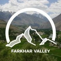
Hi, I make a terrain on arma 3 (Farkhar valley ) When i make pbo with pbo project, there is troobleshoot and error log " checking config.cpp's for land_xx..." and there are many objects error " error P3D: unknown odol format". An idea? Can you help me? Thank you Best regards
-
Delete/Destroy Minaret on CUP Map
lawman_actual posted a topic in ARMA 3 - MISSION EDITING & SCRIPTING
I feel like this should have been asked and answered somewhere already but I haven't found it yet. I'm working on the Takistan CUP map and have just discovered that the minarets are indestructible. This is most unfortunate since I've just spent a while working on a script to detonante an IED inside one which I was really hoping would bring the building down. I was looking into ways of destroying and deleting objects that are already part of the terrain but haven't yet been able to get it to work with CUP buildings. Is there a way? -

Turning off collision for terrain objects possible?
lunatic SMC-1 posted a topic in ARMA 3 - TERRAIN - (BUILDER)
So I've got a small problem with my terrain. There are a lot of bushes wich have collision. Usually that's totally fine but when there are big fields of bushes, those will block shots far too good. (making infantry within those fields nearly invulnerable) So I'd like to turn off the collision on those bushes to offer better gameplay. Is this possible at all? And if so, HOW do I do it? I haven't found any setting or option. (Of course I could rework all fields so that they just consist of a texture with those bushes added as clutter. But I wanted them to be good spots for hiding. And clutter will disappear on lowest gfx setting ingame, wich completely ruins the purpose of those dens bush-fields) -
I've been playing Arma 3 fine but recently my game started having these Terrain issues. I don't really know what they are or how to fix it and i tried to look for it somewhere else but couldn't find someone with the same problem. https://gyazo.com/1d525042839229882e872bc5b383818f - A picture of the issue. Please help I do not know how to fix this.
-

Buldozer: Extruding hills and valleys problem
Colince411 posted a topic in ARMA 3 - TERRAIN - (BUILDER)
Every time I try to load my map into buldozer, it loads until it gets to "Extruding hills and valleys". When it gets here, it stops loading and if i try to do anything it says that buldozer has stopped responding. -
Dear all, Until this day, I've added polygons and shapefiles directly in Terrain Builder. This is ok for smaller terrains, but definitely not for the ones I'm doing now. Now, for the past two weeks I've been trying to add OSM data to my terrains. I've followed these two main tutorials: Terrain Processor PMC Editing I appreciate the efforts, but I've tried everything I could and these simply are too incomplete to successfully finalize a map. For instance: In TB maps need to be of a power-of-two size, such as 10240. It is rather unclear how you can ensure that your satellite map is of this size. One solution is to select a square size in Terra Incognita, but then the coordinates you specify will not match exactly the ones of the map that will be downloaded (you can try this yourself, just save a square map selection from Terra Incognita as OziExplorer and then open it up in QGIS: the area will extend the coordinates you first entered). This means that if you use your reference coordinates you entered in Terra Incognita, they will be off for all of your other downloads. All the tutorials specify WSG 84 / UTM Zone 31N, however all of the downloads from Terrra Incognita, OSM and even OpenTopography are in WSG 84. It is far from clear when these conversions should happen, and how. Most of the times I end up having portions of data in completely different areas of QGIS even if they all are in the same Coordinate System, after following instructions. Once you export a reference height-map from Terrain Builder for a 10,240 sized terrain, the coordinates will extend from 200,000 - 210,240E and from 0 - 10,240N. All the tutorial specify to move the roads & other OSM data by switching the WSG to Zone 31N, but the scale is always off. I was able to move the elements but then they covered a tiny little portion of the destination area. When should the scaling happen? One of my areas is in Afghanistan, which is in UTM Zone 42N. Tutorials say you should use this when importing the data, but they also state that in Terrain Builder it MUST be UTM Zone 31N. This is so confusing and it doesn't help understanding what to do. This is such a pity. My best option is still to go ahead and draw 1,000+ roads and 700 polygons for forest areas BY HAND. Doesn't sound like a "best option". Hence: has some kind soul posted somewhere a precise how-to example workflow with screenshots or videos, so that it can be really clear what it must be done, in what order, etc? I'm pretty familiar with terrain building (latest map Kastellorizo is currently #1 on Steam's workshop), would love to contribute more and help back; however, I'd love to have someone finally dissolve clearly what is a good WORKFLOW to make all of this happen seamlessly. ....Pretty please? :) _SCAR.
-
While I've kept the IRL island name, this terrain has been largely altered from the real island for various reasons. Besides the buildings and vegetation, I've chopped the top of the mountain off, altered a lot of roads, etc. However, it does still resemble the real place in some ways. Iwagi is a small island located in the Ehime prefecture, kinda in between Okoyama and Hiroshima. I'm planning on using assets from the Apex expansion, and so it will require having the expansion to play. Right now, it's a total of 6x6km(I guess that could possibly change if it's too small). The island itself is roughly 4x5km. I'm using a cell space(hoizontal scale) of 3m, which is slightly less than what is suggested by all the Arma terrain gurus, but I'm hoping with it being a pretty small terrain it will work out alright. While I tried to keep a lot of places true to it's IRL form, I'm mostly limited to Google streets and as such I'm completely winging most of the island. Besides that, it needs to be military friendly.. so I completely chopped the top of the mountain and I'm going to put a military base there. =] I think I started working on Iwagi in February of this year. Originally, I had started with a completely custom terrain taking bits and pieces from all over the world in Google Earth Pro and piecing them together like a Frenkenstein. After a year of killing myself I decided to jump into a smaller terrain and use a real world place. This will be my first terrain for anything. Being as small as it is, I'm not sure it will be suitable for anything milsim related(hopefully I'm wrong), I'm hoping to be able to use it for Battle Royale and/or maybe some survival mods. GOALS: - I want to keep the mod filesize as small as possible. Thus, a smaller terrain with very limited user made content/models. - I don't want to require the user to have any other community made mods loaded to play on the terrain. TO DO LIST (as of 14 Sep 2016) Finish surface mask. Finish sat map. Finish watershed erosion and reservoir objects. Place random rocks. Finish rock outcrops. Fix mixture of vegetation in forests, add rocks and fallen trees. Finish military housing area. Finish military base layout and objects. Finish airport runway, objects, and buildings. Remove all vegetation from roadways and under buildings and other objects where it's noticeable. Set water level. Check AI movements along roadways and bridges. Have all bridges placed and remove road textures from underneath. Place road intersections and transitions. Finalize clutter mixture for all surfaces, no texture issues, set color and wind variation. Fix all road gradients, remove protrusions, smooth. Place polygons for vegetation. Place back roads and trails polylines. Place secondary roads polylines. Place main highway polylines. Put together a rough sat mask for ground textures. Make a place for a large military base and housing. Sculpt a rough height map with L3DT. Put together a rough sat map to use as a guide. MEDIA IRL Location: https://goo.gl/maps/YMEwqNyjmD32 Wikipedia: https://en.wikipedia.org/wiki/Iwagi,_Ehime Photo album: http://imgur.com/a/hqQSr I don't really have many pictures or videos yet, but I'm usually streaming on Twitch when I'm working on it. Once I can get it working in Arma I'll take some snapshots and make a video. https://www.twitch.tv/cring0 https://www.youtube.com/user/cringocringo I'll be back once I have more. If you have any questions or suggestions please let me know.
- 71 replies
-
- 13
-
-
I am trying out the Terrain Processor Tutorial but I have problems to succeed the Heightmap step. I downloaded the corresponding heightmap "n50_e014_1arc_v3.dt2" from http://earthexplorer.usgs.gov/. Then I reprojected it with QGIS (Raster > Projections > Warp (Reproject)) to "tut3.tif". And later I converted it to ASC (Raster > Conversion > Translate (Convert Format)) to "tut3.asc". Now I am trying to process the heigtmap with the Terrain Processor and the "HeightmapGeneration.tpp" project. I have waited over an hour but the Terrain Processor did not finish the task. So I really need help with this. How can I process a heightmap from earthexplorer with QGIS (or an other tool) to Arma 3? I uploaded all files to Dropbox. Thank you for your help.
-
Hanter's Gorge By Bushlurker As most of you will be aware Bushlurker, a well respected member of this community, sadly passed away in January. During the development of the Imperial Assault mod I approached Bush to ask for his assistance in creating a terrain for the mod. Despite the fact that he already had a lot on his plate he very generously agreed. He chose to do Tatooine and specifically a region called Hanter's Gorge. What is Hanter's Gorge I hear you ask? Fair question and when he told me I had never heard of it. In fact you wont actually find it listed on most maps, but you can see it listed on this picture here (no. 6): For those that saw our first live stream, this was the terrain we used. Unfortunately for a combination of reasons we were unable to get the terrain to a state in which it could be released. With the news of his passing I have been asked to consider releasing the map as a tribute to his fine work and honour the many contributions he made to the community. I'm more than happy to do this however I have never had the time to learn the terrain tools so I will need some help. Status of the map The terrain itself is done but is completely barren of any objects, this includes the basics for any map e.g. rocks. The map has no in game map picture The map title has a typo "Tattoine" instead of "Tatooine" The map has hard cut off of hills on all sides. I understand it may be possible to give the map endless mountains I've made a little video with a fly through of the map in an unfinished X-Wing from the cancelled mod. So where to from here? As I see it, there's a few options: Release it "as-is" with all its outstanding (minor) issues and lack of terrain objects. I have a packed version Bush sent me which can be released immediately. This will be the default option if I dont receive any offers of help Fix all the outstanding issues and add some appropriate nature objects. Bush was kind enough to send me the source files so this is definitely possible. Go all out and make a proper Tatooine map complete with buildings and towns. This is going to require a lot of help and would take time Please share your thoughts and if you would like to help out please send me a PM. Cheers Pomi
-
Hello guys, I'm new to this area and would like to know more about how to create my own island for ARMA 3 on the basis of real data. Recently I've come across a Russian-language article in STEAM workshop which described the process of creating an island on Google Maps. I used Google translate to understand the article but it was still quite complicated and a part of the article was not clear to me. Perhaps, some knowledgeable people would find it easier to understand this. I would be very grateful if any of you agree to write a similar lesson! Here is the link to the lesson (rus): https://arma-play.ru/kak-sozdat-kartu-po-google-maps.html And here is an example of the result in the steam workshop: http://steamcommunity.com/sharedfiles/filedetails/?id=844987995&searchtext=
-
I download a map from armaholic and convert it to .pew. In Visitor 3 and Buldozer i have a nice work. All objects and etc. are a good worked in Buldozer and Visitor. But after Export .wrp and Bynarize i have some ingame problems. There are no roads on the map, and neither roads nor objects are displayed on the "minimap" itself. Only the names of cities from the config. Tried a lot of options with the replacement of the roads themselves. I tried to add MLM for road models (although they worked in the Bulldozer before). Very much I ask to help or assist me and I ask a pardon for bad English. Thank you
-
Mapname: Orcas Island Status: ( 20.05.2017 ) Version: 0.1.4 / pre Alpha Mapsize: 600km² Largest Island: 148km² Current Object Count: ~ 70.000 Gridsize: 4096 Cellsize: 6 Mapsize: ~ 600km² Satelite Image: 24576x24576 Pixel Hi Community. After 2 years from my last release, and stopping some other works, i am happy to show you my current new project. I work from my home office, and can spend between 4 - 6 hours per day, for developing this terrain. If u want to support me, or if you have any questions about terrain creation, visit me on discord, facebook, youtube or patreon.
-

[WIP] Russian Fjords Terrain (фьорд) + Screenshots
l4z0rr0b0tz posted a topic in ARMA 3 - ADDONS & MODS: DISCUSSION
Happy Saturday! I would like to share some pictures of a terrain I've been working on for the last few months. I am planning on releasing it either on Steam or Armaholic very soon! I am using it as a testing ground for some custom winter-themed .p3d objects (which I am new at making). This is my first terrain and my first mod, and if I were to start over again I'd do a lot of things differently, but I want to publish this either way because I think there needs to be more arctic themed-maps. Right now I am more interested in starting a new project than I am developing this one much further, so I would potentially be open to sharing the source files with someone if they wanted to further develop this. Russian Fjords is a top-secret government military zone, where high tech weapons, vehicles, and equipment are developed and manufactured. It is centered around a deepwater bay in the arctic ocean, and there is only one well-guarded road in or out. The terrain design is somewhat experimental, with some underground tunnels and a high resolution heightmap. The map could be used for sabotage, espionage, intelligence gathering, or even some kind of James Bond themed machina. Honestly you can use it for whatever you want, it's just not really designed to be used for traditional mission based gameplay, it's more meant as a decent-looking, immersive, cinematic landscape than anything. Features: - 8x8km Arctic Map with 6 custom ground materials (Thank you to Dmitry Chugai of texturelib.com for the ground textures) -Heightmap, Attributes, and Sat map created using L3DT Pro and MS Paint - Unique modeled and textured .p3d objects (Snowy fir trees, space rocket) using 3ds MAX and GIMP - 10,000+ hand-placed objects - A long road which goes all the way around the map and took foreveeeeer to level out - An industrial port, and a military airbase, and several military research areas - Several road tunnels - No mod dependencies, should be compatible with any other mods Known issues: -The stock arma 3 rocks do not look "Great" since they are not covered with snow. When I started this map I did not know how to do custom objects at all. -I have not tested this map with AI and don't know how they'd behave, especially in caves/on ledges -The caves are questionable and I wouldn't recommend making a map with them the way I did. The rocks do not occlude light as you'd hope. - Because the heightmap resolution is 4m, some areas are sharp and bumpy, and depending on your terrain LOD setting, distant terrain can look kind of bad. On my next terrain I'll be using at least an lower heighmap resolution to prevent this, but I am not planning on going thru the entire map and fixing every bump at this point - The ocean goes from shore to super deep very quickly. I do not plan on fixing this - I have messed with the rain settings in config to try to make the rain look more like snow but maybe some people will think it looks funky now. I think built in snow support in Arma 3 would be sick, but for now you can at least use some snow scripts (http://www.armaholic.com/page.php?id=29156 is one snow script, but the PPEffect color correction can make it very bright and hard to see anything during the day. tweak the script as necessary) - There may be issues with my custom objects that I'm not aware of, I'm very new to making objects Planned features: -Creating snow-covered clutter, and objects such as bushes and rocks, maybe icebergs, improving the look and functionality of objects -Adding some more docks and smaller decoration-type objects such as fences -Possibly Adding some runway overlays -Properly naming and labeling all locations on the map in Russian/Cyrillic -Possibly moving the zone of the map north so that the days are shorter -Continually improving my understanding of how to write a proper config (snow particle effects for driving in the snow is one thing I have yet to master) Please let me know if anyone would be interested in working with me on this or a future projcet! I am open to working with others! Thank you! -
So i just updated pboproject to version 2.11.6.24. And now everytime i try to crunch my terrain it stops with the following message(no warning label): <searching for cfgworlds.nameofwrp> there is class tiad_greece.wrp in cfgworlds Now i mention the update because it didnt have a problem before the update. So my question is did anything change in regards to the wrp setup in the config,cpp or is this a pboproject bug? Thanks for the help.
-

[Terrain] Khogyani, Ghazni Province, Afghanistan (Release Thread)
Drifter posted a topic in ARMA 3 - ADDONS & MODS: COMPLETE
Khogyani, Ghazni Province, Afghanistan ALPHA Version Notes: This is an ALPHA version of this terrain, I still have lots of work to for the best looks of this terrain. For now most of the terrain is flat, in future updates I will be adding more ditches and bumps in the ground to add a more realistic feel to the terrain. Don't expect too much from this release, as I just want feedback about the terrain and some suggestions about the ALPHA version. There are a few issues with this terrain, biggest issue is the 2d editor and navigation map not showing the gray outlines of objects and houses, along with green shapes and circles marking tree lines and bushes. About this project: This terrain is based in the Ghazni Province of Afghanistan. For a google maps location click here. This terrain will be as close to the real life satellite images. The structures will be different, but the compounds layouts, roads, foliage and geographical features will be as accurate as I can get them. This terrain is intended for missions like foot patrols. For those realism units or groups that like to do some foot patrol missions, this might be a terrain to try out. Required Addons: JBAD_Buildings Release State: v0.1-Alpha v1.1-Beta v2.1-Final Release Stages: Features: Multiple towns and villages. Accurate tree lines and farms. One small outpost. Rivers and Creeks. Complete road systems and foot paths. To do for v0.2-Alpha: Rocks. Foliage and Farms. Terraforming. Some buildings and compounds. Pictures: Download: Mediafire - http://www.mediafire.com/download/og0s8od1dfw2g2w/Khogyani+v0.1-Alpha.zip Thanks to: MilkM8n and smokedog for Jbad Buildings ArmA 3 community -
Hello! I'm currently making a map without an airport, is there any possible way we can do this? I've had two results so far, one of them being with no input in the ILS arrays: it would end up in an airport being placed in a random location (same happens if you have no roads but just that there'll be random roads!), or in a error message of "No ILS assigned" _(if I input one empty value of like, zero) on start-up of the map. I'm gonna add one to my other map, but the one I'm currently making is an unhabitated island and there isn't much of a point for it to have one as it is sort of a small terrain of 2048x4 and the island is very narrow. Anyone have any clue what I could do? Thanks you!
-
Hello there! I've been looking into trying to tinker around and learn how to make snow maps for ArmA. Although the satellite image and other settings are very simple to do, I was wondering - but what about the trees, the clutter, and the houses? They'd all look as if they were normal, green trees, green grass/bushes, instead of white or houses sort of covered in Snow. So here I ask, does anyone know anywhere we can get assets (Mods or alike) for a winter map? Or reskins of current in-game things to make them fit in a snowy environment? Also, it'd be really nice if it comes from an accessible author or if they're allowed to be publicly used! Thanks you!!! Kindest regards
-
Hi guys, So i have been deving a terrain for quite a while now but i have run into a massive issue. I open terrain builder (as admin) and that works fine. then i go to open my project and that is where shizle hits da fan XD. It seems to start opening my map then it crashes. I have verified the integrity of a3 tools and that did nothing. i also ran a troubleshoot compatibility on the terrain builder exe and that did nothing. Have you got any ideas on how to fix this as this only started today. When i checked yesterday i could open and close the project fine ( and did so many times as i was making roads) Thanks in advance Harry
-
Hello everyone! Here I am pleased to announce, that myself, alongside all the help of fellow ArmA 3 content creator and players, I've finally finished my first ArmA 3 map that I had wished to do for so long! Teumess! http://steamcommunity.com/sharedfiles/filedetails/?id=870872623 Teumess Teumess is a fictional island, loosely based off of Mykonos, Greece. It is one of the Greek islands along Lemnos and Agios Efstratios (Altis and Stratis). It is a 10KmX10Km map (with 65.071 objects), split onto one main island and six smaller islands, the main island being of approximately five kilometers in length, with mountain peaks of up to two hundred and thirty meters, also along deep seas that go as deep as three hundred fifty meters depth. This is the first map I ever made, it's made with lots of learning, effort, and love. I take it as my start onto the more advanced modding aspect of the community, this game has given me many years of entertainment, fun, and enjoyment; and I've decided to start giving back to both the game and the community. Requirements Subscribe, play, and enjoy! 🙂 Map The map is focused mainly on close-quarter encounters and infantry movement, although other things can also still be used. There are ten cities in total, some of them being urban and some rural. There's also two military bases and few landmarks scattered around the map. If you find any issues or have any suggestions, feel free to tell me. This map is still up to have revamps and updates in the future once I get around to doing them or if there's some cool suggestions people would like to see. Anyways, thanks you very much for taking a look, and I hope you will have joyful journeys, adventures and battles on this map! License CC BY-NC-SA 4.0: https://creativecommons.org/licenses/by-nc-sa/4.0/ Credit for the fox screenshot in the preview image: © Donald Macauley SPECIAL THANKS: sleepydragon4888 - Snake Man - KnowIton - MikeRo - Jakerod - D3F3CT3D - SAUL - M1lkm8n - Jake Pauling - Pennyworth - RaveTheWolf Why the name Teumess and the fox in the picture? https://en.wikipedia.org/wiki/Teumessian_fox Thanks everyone from the ArmA community and Bohemia Interactive itself for allowing for this opportunity to create our content and to have such a beautiful playground to play in! I wanna thanks everyone in the Terrain Makers skype and discord chats for all the help and support, same to all my friends and fellow ArmA players. I would've put pictures in here and etc but I don't know much of the formatting, so yeah, this is as good as I can do for the forum post! If you have any inquiries, suggestions, or etc, feel free to post here or in the STEAM link! Be advised it is my first map ever and I still have a lot to learn, thanks for the space and the time! 🙂 With no further ado, I wish everyone the best of luck, hope you enjoy!

_Looks_out_over_the_fog-shrouded_A_Shau_Valley._-_NARA_-_531459_tif.thumb.jpg.bb707a83716e4268ca67c3680f733068.jpg)