

mir_o
-
Content Count
24 -
Joined
-
Last visited
-
Medals
-
Medals
-


Posts posted by mir_o
-
-
On 6/7/2018 at 6:35 AM, -REALM- said:Hey @mir_o! This plugin looks great but I have difficulties using it. Will this tool be inside of DayZ Standalone modding tools in future? Also will you write more documentation about how to use it? Thanks!
Hi mate sorry for way too late response, I don't expect to include bLT in DayZ Standalone modding tools, at least it's not clear to me yet what's the advantage having it there. Regarding documentation, this may be postponed as I'm now in re-designing phase as I'm about to start rewriting whole bLT into Blender 2.8.
On 12/31/2018 at 6:53 AM, HorribleGoat said:@mir_o what is the correct version of Blender to use now that 2.79 seems to have reached last stable release and development has moved on to 2.8?
bLandscape tools do not seem to work with the latest 2.79 though.Thanks for the notice mate, I'll have a look.
-
17 minutes ago, HorribleGoat said:Excellent news again! Very exciting times for Arma Terrain community.
One question, are there any limitations on mask/ satellite image size?right now yes, Ross (my testing hero) found out that OpenCV is not able to open raster >30000px(+/-) ... I'll probably have to fallback to GDAL, needs more investigation though, but as mentioned in Plans for v0.2a I want to support loading of split images
-
 1
1
-
-
Hi guys!!!
It’s been over four months since my last development update, so what’s happened in this period of time? A lot, but mainly the v0.2 of bLandscapeTools were released, well over a month ago!!! On December 25th, as a christmas gift, announced at Discord and Skype, available at https://github.com/paxetgloria/bLandscapeTools.
What’s new in v0.2
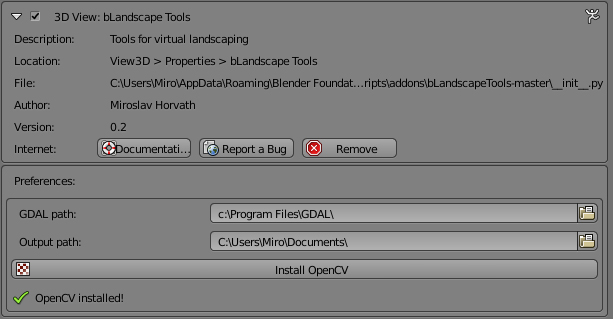
OpenCV library support
As mentioned in the previous dev update I decided to have this library under the hood as well, for many reasons, but as I wanted to have installation of bLT(and its support libraries) as easy as possible I had to figure out how to automate OpenCV library installation so it’s more comfortable even for newbies. Eventually, I made it, but it was a hell of challenge.
You can find the Install OpenCV button in the addon’s preferences. More info about the installation can be found at https://github.com/paxetgloria/bLandscapeTools/wiki/Installation-guidelines .
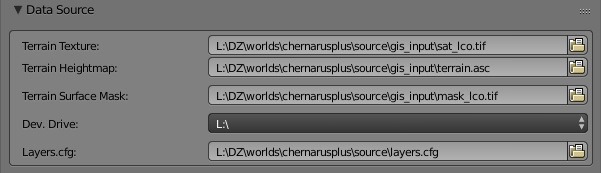
Surface Painting
I got it into a usable state. It requires you to provide the following inputs within Data Source tab:
Terrain texture
Terrain surface mask
Developer drive
Layers.cfg
bLT sets up all brushes automatically, in case user has detail surfaces saved in PNG format bLT uses them to create brush preview icons, otherwise surface color defined in layers.cfg is used.
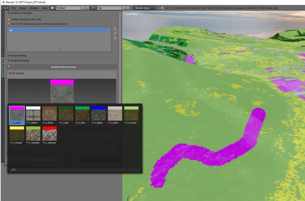
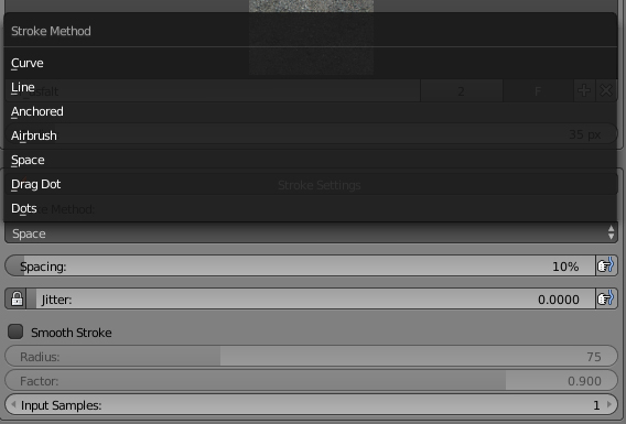
I added Blender’s default Texture Paint settings like Stroke Settings to Surface Painting tab to provide you with some nice ways how to perform your strokes.
Also added handy viewport settings to help you while painting surfaces, note that I haven’t found any use for Blend type(blending of terrain texture with surface mask) yet, but I’m leaving it there for now, if anyone finds it useful.
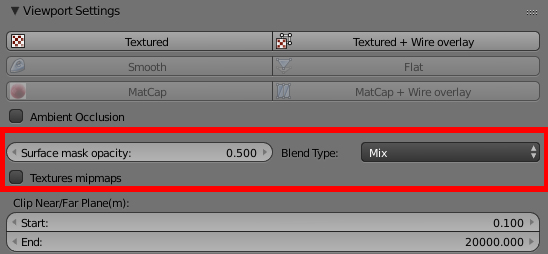
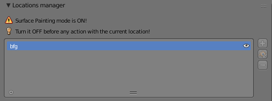
All paint changes are being saved to location’s surface mask only when user disables(turns off) surface painting mode. In this regard, I added a warning messages into GUI to inform you that you have to do so, before trying to commit your location’s change.
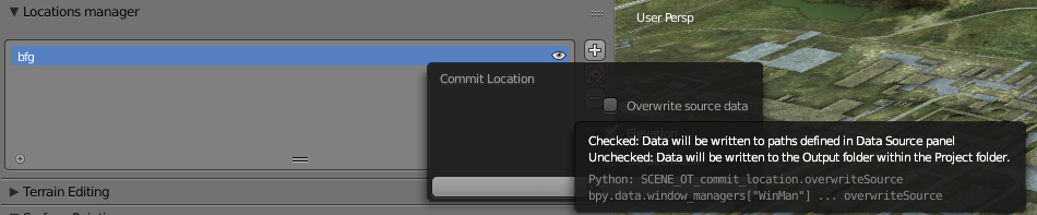
Commit Location improvements
When commiting a location, user can decide where he wants to have data written to, either to original source data(defined in Data source tab) or Output folder within the current Project folder.
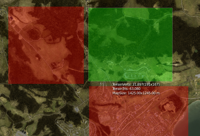
Occupied locations
While importing a new location it provides a visual guide what areas are already imported to prevent using parts of already occupied locations in other locations(you may overwrite data when committing a change)
bLTilities - Check surface mask
I added a super handy utility to check your surface mask for possible errors, read more in documentation https://github.com/paxetgloria/bLandscapeTools/wiki/bLTilities#check-surface-mask
Plans for v0.2a
Realtime surfcase check - similar to what bLTility Check surface mask does, but in real time
Import support for terrain texture split into separate files
Support to read/write tif elevation files
..and possibly a better bLT messages logging so user doesn’t have to have Blender’s System Console turn on to see , the plan is to misuse Text editor for that, wish me luck.
If you'll find a bug, report it here(hit New issue button) or if you just want to share your thoughts, please don't hesitate to contact me on Skype or Discord. Of course, you can leave a message here on forums.
Cheers,
Miro
-
 2
2
-
-
Damn it, I keep login in with the account I'm not using anymore, sorry for the confusion, so the above answer it's actually me :)
-
2
-
2
-
-
Hi guys,
It’s been exactly two months since my last update and it’s time to write about the progress again. First of all I had to apologize for the delay(I promised to have another version to play with at the end summer holidays). For almost a month, me and my family, was struggling with some virus so most of my free time went to getting us well and relaxing. On a positive note, I had a break, zoomed out, from coding and just thought about what I’ve done so far and got a clearer view how to progress further.
Quite a lot has happened in the code, pipeline and workflow. Let’s have a look!!!
1 Terrain modification
1.1 Sculpting
The most useful sculpting brushes and their features were moved directly to bLT’s Terrain Editing tab for faster and easier work flow. User doesn’t have to switch between various modes(Object, Edit, Sculpt, Paint...) and then going to the right tab, now it’s all at one place.
1.2 Mesh based terrain editing
Sculpting in some cases may not be ideal, especially in cases when user needs to tweak terrain mesh in a very precise manner.
With mesh based terrain editing user basically models the shape of an area that needs to be tweaked and then uses Blender’s basic modelling tools to get a desired terrain shape.
Another advantage of this approach is the fact that, in terms of Blender, editing is done via so called modifiers, which means that changes are not applied to a terrain mesh until user is done editing(applying changes). In practice, if a user tweaked terrain in one location and later decides to have these terrain changes in other location he just basically drag terrain modifier over to a desired area.
There are currently two ways, the first one, Assign Mesh Terrain Modifier, assigns modifier to a selected map object(eg. house). When user moves an object with a terrain modifier assigned, the shape of terrain(defined by the mesh) goes with an object.
The second one, Add Mesh Terrain Modifier, just adds a simple plane modifier(not necessary to have an object selected) to terrain.
Both modifiers have, by default, a square shape, but it can be eventually modeled to a very complex shape.
1.3 Spline based terrain editing
Similarly to the mesh based editing, spline based editing involves modifiers as well. The only difference is that the shape of a modifier is based on a spline. This comes handy when user needs to flatten terrain under a road on a steep hill, for example. User can now control width of a spline as a whole or at desired control points of a spline as well as the tilt.
Another feature of spline based editing, which is still work in progress, is a possibility to paint weights of how much a terrain mesh is affected by a modifier(see picture below). In this case spline based terrain changes were filtered out by painting zero weights(blue color) in parts where a bridge will be placed.
2 Surface Painting
This feature is currently under heavy development. There were two major friction points:
1.
I thought I’ll be able to implement this feature without any 3rd party libraries necessary, but I eventually decided to use OpenCV, which is definitely a good decision as it opens new possibilities in raster processing. Unfortunately it took me some time to figure out how to make it easier for a user to install it. I’m still not satisfied, as user has to install Python 3.5, even though Blender comes with a slim version of Python 3.5 pre-installed. Anyway, I can promise that I’ll automate as much steps as possible so user won’t struggle with it.
2.
This one is still kind of an opened issue, but not a showstopper for the surface painting anymore. So what was the problem?
Since I decided to release bLT and have support for RV Engine within bLT, I always wanted users to have a possibility to load Arma’s map objects(binarized p3ds) into my tools so they can use all the handy features of bLT while all the map objects are loaded in the viewport.
So I went, with a little hope, to BI’s CEO Marek Spanel and Arma3’s Project Lead Petr Kolar and asked them if BI would be willing to release textured last LODs of all Arma models converted into blend files(Blender internal format)... and they said ‘NO PROBLEM, GO AHEAD’!!!
Although I was really happy for this ‘little’ success, I was realizing what kind of diversion from Surface painting development this is going to be. I had to write a tool to extract last LODs from p3ds and although I did my best, some p3ds are simple pile of mess. So I have list of like a hundreds of models which will have to be converted semi automatic way. Another time consuming part was to figure out how to load these objects into a project. For now I’m going to use a solution I also presented at the Blender conference, but I hope the ongoing Asset management project for Blender will bring in some advanced tools for assets management.
3 Minor features
The new Blender 2.79 brought in a cool feature called custom application templates which allows me to set up custom appearance, settings, key mapping of bLT in a simple way. It also finally allows me to set up custom splash screen when bLandscapeTools template is picked.
So now, with all the above being said, I don’t want to set a solid dates when another version of bLT will be released. First of all, I need to finish Surface Painting feature and then make objects loading a bit more solid and stable and I expect this to take around a month.
That’s it for now.
Thank you for your support!
Miro
-
12
-
-
On 27. 7. 2017 at 7:51 PM, NeoArmageddon said:Is there already a way to import unfinished TB projects?
Well this first version will support terrain mesh editing, other features like surface painting, objects placement and possibly wrp export will come after it. So the current workflow still needs TB to import terrain tweaked in bLT and export it into wrp.
-
2
-
-
Hi people,
while I'm still adding some info into bLT's documentation at https://github.com/paxetgloria/bLandscapeTools/wiki/bLandscapeTools-Tabs, you're already free to give the bLandscapeTools a try... https://github.com/paxetgloria/bLandscapeTools
I made a short video how to install bLT, Blender and GDAL for you.This is a testing build, a very first one so be patient!
Although this version is more for users who already knows Blender, especially viewport navigation, using the sculpting mode etc. anyone is more than welcome to just set your source data and get your first location loaded into Blender. Lappihuan was able to get his terrain into Blender even without any documentation so I hope the current workflow is pretty straightforward.If you'll find a bug, report it here(hit New issue button) or if you just want to share your thoughts, please don't hesitate to contact me on Skype or Discord. Of course, you can leave a message here on forums.
Note, please don't try to import your 4096x4096 terrain into Blender at once, as that's not how bLT is supposed to work. You'll find info about Locations idea soon in the documentation.
Cheers and happy blending,
Miro
-
7
-
-
Hi guys,
I'd like to share my professional life jubilee with you guys... today I'm 10 years at Bohemia Interactive/Bohemia Interactive Simulations, 10 years of sweating blood while working with RVengine and its tools, as well as feeling proud when looking back and realizing what I helped to build.
The reason why I'm posting it here is that I've been doing my best(progress tracked here) to release '0th' version of bLandscapeTools exactly with this jubilee, but it still needs some love and I expect to have it ready for the release at the end of summer holidays. The '0-th' or 'Introduction' version won't be as features rich as the version I showcased at Blender Conference(only terrain sculpting will be packed in) because I'd like you guys to become familiar with Blender's Interface and bLT workflow, at the first place. This version should illustrate the basic idea and concept of bLT and open a discussion about what features should be implemented next.
So while waiting for the release and enjoying the summer, have a look at some Blender's tutorials I collected for you. If you guys will find any other useful tutorials on how to get familiar with Blender(mainly viewport, objects manipulation), please share it with me and I'll add it here and later to guidelines at bLT's github page. Thank you.
Blender Beginner Tutorial - Part 1: User Interface
https://www.youtube.com/watch?v=JYj6e-72RDsBlender Beginner Tutorial - Part 2: Moving, Rotating, Scaling
https://www.youtube.com/watch?v=s05DiCEDVGEHow to use Blender : Beginner Tutorial
https://www.youtube.com/watch?v=JUhWdGcOHPwI also would like to thank you for the kind words and support I'm getting from the community. Appreciate it a lot :) ...
Cheers,
Miro
-
12
-
-
Hey guys,
first of all thank you for the kind words, really appreciated it.
The first feature I'll release with BlenderTerrainTools will be terrain editing and sculpting. I'd like to ask you what do you expect from such a feature, what's the typical problems(bottlenecks) you're struggling while editing elevation, what functionality you wish to have? I need to know this in advance so it can be implemented and then tested, ideally at once. Let's discuss it here, Skype's Arma 3 Mape Terrains channel, or Discord's #terrain_makers channel ...Thank you in advance for any kind of input.
Edit: here's a video showing one of many use cases of terrain editing in BLT https://www.youtube.com/watch?v=2CgBaZc5o1Y ... what do you think could be done better?
Cheers,
Miro
-
2
-
-
Hi map/terrain/environment/world… makers,
this is, after working at BI/BISim for almost 10 years, my first topic created here at BI forums. In my defense, I’m mostly active in Arma 3 Maps Terrains Skype’s group, but the topic I want to share with you deserves to be discuss here(skype has short memory and is not as comfortable as forums, for such kind of discussion).
The Topic?
It’s of course the bLandscapeTools(bLT), an addon for Blender I’ve been already working on for the last 8 years. The main reason I started this addon was:
-
already knew Blender
-
wanted to improve my python scripting skills, as I like to automate or at least speed up processes
-
many handy world creation features were not available back then, are not available now and will never be implemented in BI/BISim world creation tools
Necessary to note that I never intended to write a tool which would take over the world BI/BISim tools, but rather try to fill gaps(small/large) in terrain development.
Blender is a 3D modeling tool(and much more), but you can’t expect fancy features which can handle big chunks of terrains with millions of objects on it, it has its own bottlenecks and limits, but even back then I could see, that the advantage of having possibility to import terrain mesh and its textures to Blender and start placing environment content much more easier way(comparing to Buldozer) or even modeling content over a terrain is a feature that will never come into Terrain Builder/Buldozer.
By sticking together Blender’s default features like sculpting, painting + powerfull API I was basically able to add many time consuming and “Visitor4/TerrainBuilder hard to get implemented” features into Blender.
Let’s stop talking for now… check out my talk at BlenderConference2016 about the Blender Terrain Tools(Edit: just currently I changed the name to bLandscapeTools) so you guys can make an image of what I’ve been working on.
There are some features which will be really hard(almost impossible) to release because they are closely bound to BI dev content like raw(non-binarized) P3Ds, but on the positive note bLT has some handy features not even mentioned in the video(like quality assurance tools)
Why now?
After the conference I got contacted by individuals and even teams, asking me where they can download the addon as they would like to have their hands on it and give it a try. So I decided to start releasing the tool bits by bits to people so they, hopefully, can have a fun time play around with bLT.
Also, the fact that this year(2017) it's going to be 10 years at BI/BISim or in other words working with the RVengine, as well as, Paul Pelosi(bushlurker) suddenly passing away, made me to do this decision and release the tool.
It’s also going to be a challenge and something new to me, releasing my tool to other people, it needs a change of thinking about the tool, fix some parts of the pipeline..etc. and that may take some time.
How?
There’s plenty of how in the front of me.
I need to figure out a way how to share the tool with you guys. Github, Blender market I have in my mind right now.
As mentioned already, there are features hard to release(raw P3Ds). In this case I’ll have to ask someone here in BI, if company would be willing to release let’s say at least last LODs of assets so they could be imported into Blender and used within bLT.
I use Blender for over 10 years, so I’m pretty comfortable with its workflow, but this doesn’t have to apply to a newcomer. Therefore, I’ll have to take some steps to make bLT even more user friendly than it is right now. I plan to make quite some tutorials how to use Blender and bLT to user’s satisfaction.
Currently, Blender development is at the stage where quite a big major changes are being implemented and to be released with Blender 2.8. There’s going to be plenty of great new features such Viewport update(supporting PBR shaders), new Layers, Workflow system and much more.
This means that I’ll have to re-think some of the bLT features to support all these new improvements once they’re released. Therefore I don’t want to do any major touches into what exists in bLT now. I hope that the improvements done for 2.8 will take bLT a few steps further again, as it already happened with the transition from Blender 2.4 to 2.5+.
So once again, I’d like to ask you to have a look at my talk, if you have any questions please don’t hesitate to ask. It will help me to move on with releasing the tool as well as to know how the features should be done to help you create a map for any RV engine related project.
When?
Release of the '0-th' or 'Introduction' version is planned on the end of summer holidays.
Progress will be tracked here.
Subscribe to my personal youtube's channel here.
Tools Github's here.
Cheers,
Miro
-
31
-
-
@ZeroG:
What kind of gameplay do you expect to have on this geospecific map? It's good to have this question answered before start looking for highres data and thinking about a level of map generalization especially when dealing with geospecific(Real Life Map) landscapes.
I can provide quite a lot of technical support as well as useful hints during map design process, as this is what I've been doing for last 6 years in BI and BISim.
What I mean with technical support... I'm still working on my Blender Terrain Tools and such project would be good stress test for the tool. It supports terrain sculpting, surface mask painting, object placement and so on, I'm also working on a technology to render topographic map for printing...
-
So, is that a hint that the tools might be released in some form for the community?I see no problem, depends on what you guys would like to have in tools. Terrain sculpting is on by default, Mask Painting is worth only if you have unbinarized p3ds, which can be imported into Blender, but someone might find Mask Painter usefull even without objects on the terrain.
...to write an addon for QGIS which would support the proces of creation of Arma maps..what processes do you have in mind??? I use QGIS a lot it's a powerfull tool, but one thing I'm afraid is canvas drawing or in other words if you have a lot of shapes loaded it's being very slow.
My idea is to use Blender to load even shapefiles and use them for example to generate forest... I did this for my diploma thesis, all processing was done in PostGIS.
So, if understand correctly, when you finish editing a part of a terrain in Blender then you 'patch' the original rasters (height or sat/mask) in correct places?yup ..exactly.
-
Hi guys,
It's nice to see that my Terrain Tool project found its way where it belongs(to Arma/VBS community) without any effort(so far) from my side.
I'm not sure if anyone noticed it but there is an interesting article in BlenderArt magazine (ISSUE 39: SPIRIT OF EXPLORATION):How did you find the article lecholas, Blender fan, ArmA2 Map Makers Channel skype chat member... ? ... just wondering :)
It is written by Miroslav Horvath (former(?) World Design Lead at BIS)Yup, I left the studio over year ago after the TakeOn Helicopters project was done, but I'm still with the "family" at BISim.
I wonder how strong computer one has to have to do this - I had troubles editing more complicated 10240x10240 sat masks in a 2D graphics program; the technique is similar as here, I suppose:).The approach in the video works, but it's very 'beginner-ish' to be used for the madness in Arma maps development :p
Of course, during sculpting or painting session I don't import whole map(heightmap and imagery) as it's not necessary, so I can edit a map without a need of powerfull PC.
I've also found a movie about this:
(it really starts about 8min 15sec)It's a shame that the video quality from the Blender Conference is so fucked up, but I plan to release a showcase video this month. If you have a questions I mostly answer at "ArmA2 Map Makers Channel skype chat".
Take care pals
-
ok cool so the Takistan Terrian(Used in ArmA2 OA, not TKOH) is really from Arizona and not Daykundi, Afghanistan?Takistan is based on Afghanistan,Bamyan province, southwest from Yakawlang.
South Asia (TKOH) border between the states of California and Arizona.
Read more here... http://www.bistudio.com/company/developers-blog/276
-
Agreed!Well, I have no problem with it :) , but it`s up to you guys, what would you like to hear/know as map development is kinda looong run involves not only placing objects into a map but also solving technical issues(both tools&engine side) related to maps, design decisions, managing people working on different maps... to pushing programmers to fix some itchy visitor bugs :)
So maybe would be good to create a new thread(or use existing one) and write down all of your questions to know areas of interest, at least.
-
Hey
It`s great to see that my interview was worthwhile also for some Arma heads as well(at least czech/slovak). About the "terrorist thing", this supposed to be a joke of course ;) .
When you ask for an aerial/satellite imagery all companies always need to know what purposes imagery`s gonna be used for. If you order it for purpose of getting a new contect from it(eg by vectorization or additional processing), sell it then and make money again and again, final offered price can be really high. LandInfo just wanted us to swear that imagery will not be used by third party company(BISim) and could offer us lower price.
So no big deal, no terrorist scenarios :cool:
So that's interesting question, if someone from BI can answered it, if they choose map data from USA because of problem with permission with real for e.g. Afghanistan data? (of course if at all US data are model for south asia terrain :))
Sometimes and especially when you require such huge area as South Asia map is, it is harder to find imagery in good quality over the whole area, it means almost zero cloudness and whole area must be captured in the same season. We were very satisfied with quality of Seattle imagery from one unnamed source so we decided to use it for SA map as well, but they cover only US land, that`s it ... no permission problem at all.
-
Screenshot please
-
... demo terrain was 4096x4096 - 10m cell... worked OKB
Weird :confused:, could you tell me what was the size of the wrp file???
I set 20m cell size but I dont think that this would increased binarization time to 8 hours, cell size is just "a virtual measure" and it shouldnt affect file size and bin time of an empty map.
Ill try to set 10m cellsize just for fun :cool:
-
I've seen an stable island with 10 meter cell terrain and a 4096 resolution file. Loads well and has a good terrain resolution
Are you sure it was 4096x4096 terrain grid? How long did take to binarize it?
My latest test with 4096 terrain grid and 20 m cell size took 8 hours(map was completly empty) to binarize.
-
Have you already tried to get 4096x4096 terrain grid into the game?
Make a test with just 20480x20480 satellite image(1pix = 2m) and 4096x4096 terrain grid.
Binarization with this terrain grid on some of my tests took 8 hours(whole map was without objects)!!! and after 15 mins of loading ingame I had to kill the application. Arma engine isnt still optimized to run such huge data and as far as I know only VBS engine got this optimalization for engine and packing line.
-
Can I use ASTER maps or should I stick with the lower res SRTM 90m for the elevation?
The best way always is to get a data into the game and see how it works for proper area(comparing resolution, size, details...). For the Takistan map we made "a trick" where original Afghanistan area of 25.6 x 25.6 km was scaled down a half to 12.8 x 12.8 to get more mountain like areas in the map(of course height informations had to be scaled as well). Propably it`snt answer to your question but I just wanna say there are many ways how to play with input height data.
1- How can I crop them and edit? Should I convert it to PNG, photoshop it up, and then convert back to DEM/XYZ for use in Visitor3? Any special settings, hints or tips on that?
I usually use Global mapper to do this. I prepare vector rectangle, which coordinates are somewhere around your location(I prefer OpenJump), save it as a *.shp, load in Global Mapper(dont forget to set proper Projection and Datum). You can tweak rectangle position by right clicking on a layer and choose "Shift selected layer a fixed distance". If you are satisfied with position, select rectangle and go to export to XYZ or png. In "export bounds" tab, check "Crop to selected area feature". You should get only the area which is covered by vector rectangle. You will have to play a bit with the "Sample spacing" to get proper terrain grid size (1024x1024 or 2048x2048).
-
Hi JR_Walker,
Is Visitor able to import a 40960x40960 sat_lco?
..propably not, Visitor 4 is optimized to import such a huge imagery. There is also possibility to import imagery which is cut to lets say 2x2 tiles(20480x20480).
I assume you`ve used terrain grid 2048x2048, right?
-
New bulldozer feature seems appeared!check OA keys... now it's possible to raise/lower terrain by 1 meter, 50 centimeters and 10 centimeters!
THANK YOU GUYS! great news!
Your welcome :) Tweaking terrain details(especially around buildings/houses) with the original 5m, 1m step was a nightmare on the maps with 4-7.25 m terrain grids
 , so my call to the programmers heaven was heard
  :yay: , I have also some more ideas how to make object manipulation in buldozer a bit easier.

bLandscapeTools - Introduction
in ARMA 3 - COMMUNITY MADE UTILITIES
Posted
Hi guys, it's great see that some of you are still using this Addon. Unfortunately, I stopped supporting the version for Blender 2.79 a while ago and I'm fully concentrating on development for version 2.9+
That being said I also stop using bLandscapeTools Youtube channel and decided to use only my personal one so I'd like to ask you to subscribe to get update on development, thank you in advance.