

Nicholas Bell
-
Content Count
396 -
Joined
-
Last visited
-
Medals
Posts posted by Nicholas Bell
-
-
Quote[/b] ]Same here, extracted the opx objects into my projects ca folder,That's not what Opteryx wrote in his message above.
It should look like this:
<table border="0" align="center" width="95%" cellpadding="0" cellspacing="0"><tr><td>Code Sample </td></tr><tr><td id="CODE">P:\opxbuildings
not:
<table border="0" align="center" width="95%" cellpadding="0" cellspacing="0"><tr><td>Code Sample </td></tr><tr><td id="CODE">P:\ca\opxbuildings
It does not require anything beyond this, ie redoing the config files, etc.
-
I think you are not understanding the most important part - you either need to resize your GE image, or take it from the correct altitude, so the scale is correct.

Using the ruler you can see that 111 meters real world = 230 pixels. Â Therefore each pixel equals .48 meters. Â If your doing a 1024x1024 map with 20 meter cells, your sat image would not be 20480x20480 at 1 px=1 meter. Rather, it would be 42,667 x 42,667 pixels. Â Obviously this is too much, so you would want to create your image from a higher altitude to reduce the size of the sat image. Â This example image was taken at a height of 383 meters above sea level. Â By doing some math you can determine that if you take the image at 798 m asl then each pixel would equal 1 meter in your sat image.
Note that you can have you sat image at more than 1 px = 1 meter, but then ArmA stretches the image to fit and it will not look very good.
Hope this makes sense. Â It's not as difficult as I might be making it seem.
-
BadBenson,
My dirt poor backhill farmers envy your tower.
-
Well what you want is the GE pixel dimension to match whatever you are using in V3. Â My sat maps are all 1 px = 1 meter. Â What height you use in GE is monitor resolution dependent. Â By taking a screenshot of GE and using the distance scale (in the lower left corner), you can determine the number of pixels per meter real world dimensions at the height of your screenshot.
I then use Fraps to snap images of the entire image, which I cut and paste together. Make sure you turn off the side bar, nav tools etc to maximize your image, and have Terrain turned off to avoid distortion. Â Very important to ensure you don't change the GE height above ground by mistake, and use the 'R' key to ensure alignment. Â Once I have the entire area pieced together I can resize it using the ratio I determined when I took a screenshot with the scale visible.
Obviously you want to get the best image, but zooming in all the way in GE is not always the answer because their image's resolution. Â Plus the more you zoom in the more images you have to take and piece together. Â Of course if you zoom out too far you lose a lot of detail, too. Â So you have to balance.
I have a registered copy of the program called Google Maps Image Downloader which worked great - note past tense. Â It would download the pieces and stitch them together for you
 Â However, it no longer works for me...my guess is that GE got wise and found a way to block it entirely (it would temporarily stop me if I got to "greedy" with the auto-downloads). Â It's still available, so maybe it's just me it won't work for anymore.
 However, it no longer works for me...my guess is that GE got wise and found a way to block it entirely (it would temporarily stop me if I got to "greedy" with the auto-downloads).  It's still available, so maybe it's just me it won't work for anymore. -
I think BadBenson's texture looks good - and damn close to this:
http://www.flickr.com/photos....3640281
which is an image he posted himself in another thread. Â So maybe he did do his research. Â

-
Quote[/b] ]It was kinda not released as far as I know but availlable anyway..I found it by search but in the request thread there is a D/L-link since a few days.Thank you!
-
Did I miss something? Where are those fine looking T-55 available?
-
Really enjoying using your mod, TonyRanger. Â It's a totally new experience.
Not sure if you can help with this little problem. Â I'm using my Razani map (not yet released) and it has a lot of mountains. Â Many helicopters when called spawn and then crash into the mountains. Â The ones which survive, complete their mission and return in the same direction. Â But instead of crashing they hover and eventually disappear - which I suppose is what is intended.
Would it be possible to manually set the altitude of appearance, or perhaps the direction in which they appear to work around this problem?
Got to say it was pretty impressive having an AI controlled squad lose a man and then call for it's own medivac. Â I'm just standing around with my jaw hanging in amazement. Â Until I got hit, started bleeding, and eventually the lights went out!
-
Although probably not helpful in this case, I have experienced really mysterious problems with cfg and cpp files causing problems without any "visible" errors in the files themselves.
I lost a good six hours this weekend when I added a new texture to the map which caused all the textures on the map to go black. Â After much frustration, trial and error, Â I cut and pasted the new texture listing in the layers.cfg from the top of the list to the bottom of the list and everything worked. Â This is not the first time this has happened.
Only a guess, but I suspect it might have something to do with spaces in the text file.
In any case it is a good idea to keep copies of cfg files that work, and when something goes really screwy to go back to a good one and retype/reinsert the changes, rather than just working on the bad file.
-
Thank you for sharing these, Smersh.
-
Yeah it's pretty easy to stick a base on the map. Â The templates at OFPEC are great. Â And one can easily modify them for specific conditions,
-
Interesting article here:
http://www.longwarjournal.org/archive....ita.php
High-water pants and sneakers are trademarks of Al Qaeda's fighters.
-
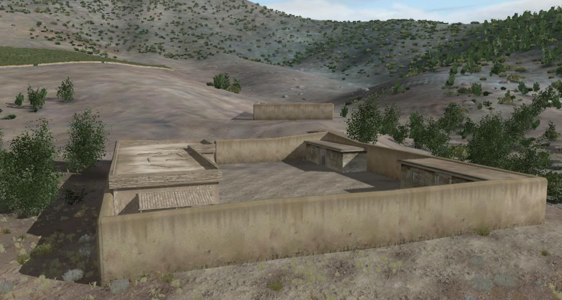
I'm quite aware of how to do it, but I do not have the right to rework and redistribute Opteryx's work without his permission. Â One has to respect his right and concern about quality and potential conflicts with his maps.
As for making my own objects - I am only in the beginning stages of learning how to create models. Â The rock wall visible in the images is mine, for example. Â My opinion is that it would be better to get something for people use now, as opposed to waiting another six months for me to make objects. Â As is, the map which will be released in a few weeks is not complete regarding other aspects not related to the buildings. Â This is going to be an on-going project which I will continue to improve and release. Â I and a few others are enjoying the map as is right now - I don't see why the rest of you can't also enjoy it for what it's worth.
No one is forcing anyone to d/l or use this if they disagree with this. Â I feel I am and have been from the beginning fully disclosing my approach.
-
Opteryx already noted the color issue. Â There is no real easy fix for this. Â Either changing the terrain or the object's textures is would take a lot of time. Â So the initial beta release will be as shown. Â I can not make any comment beyond that - other than I am grateful for Opteryx's work and permission to use it.
-
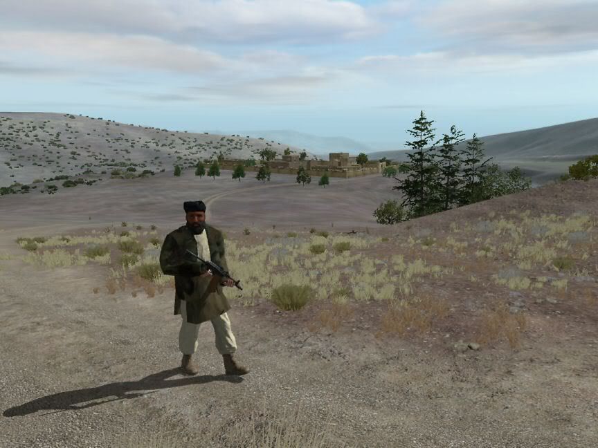
I can't answer your question, but they do look pretty darn good. Â I've been studying a lot of pictures and video for my Razani map, and these look very familiar. Â I guess this in an area where they don't plaster the walls? Â I've noted it is done in some areas and not others. Â Wonder what's the reason behind the variation.
You even have the roof support timbers!
-
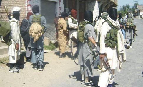
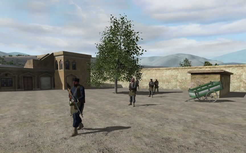
I really like the look of the Lost Brothers Mod Taliban. Â My thanks to Miles Teg.
As I previously stated, they really believe in "every man's home is his fortress". Â No wonder attack by Predator is preferred by the US and one reason why the Pakistani Army has had difficulties here.
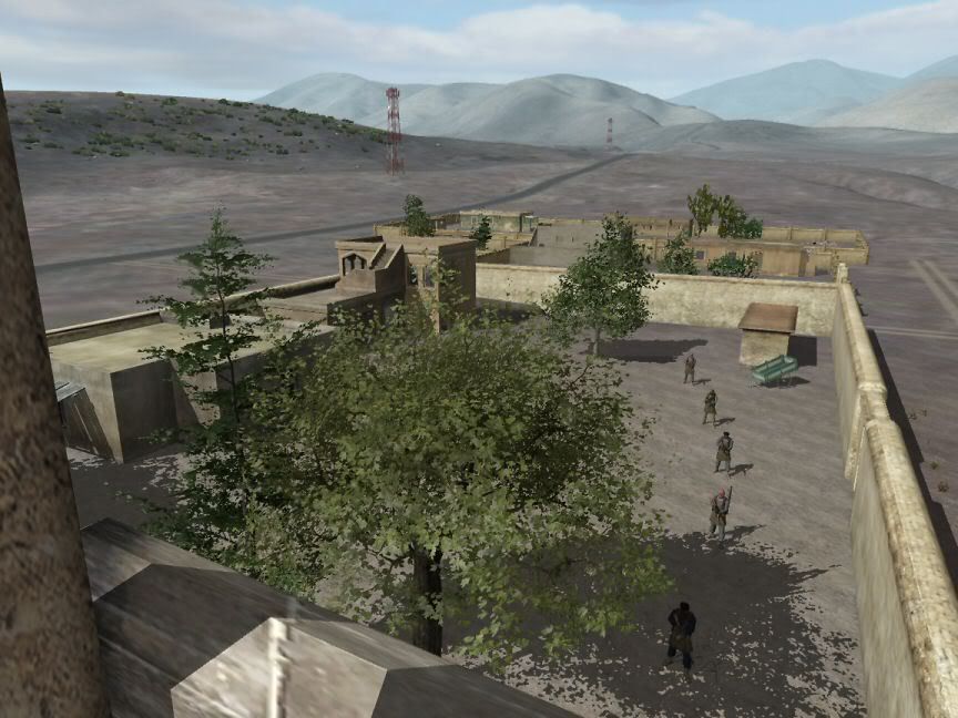
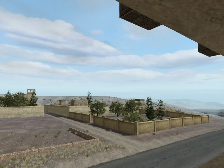
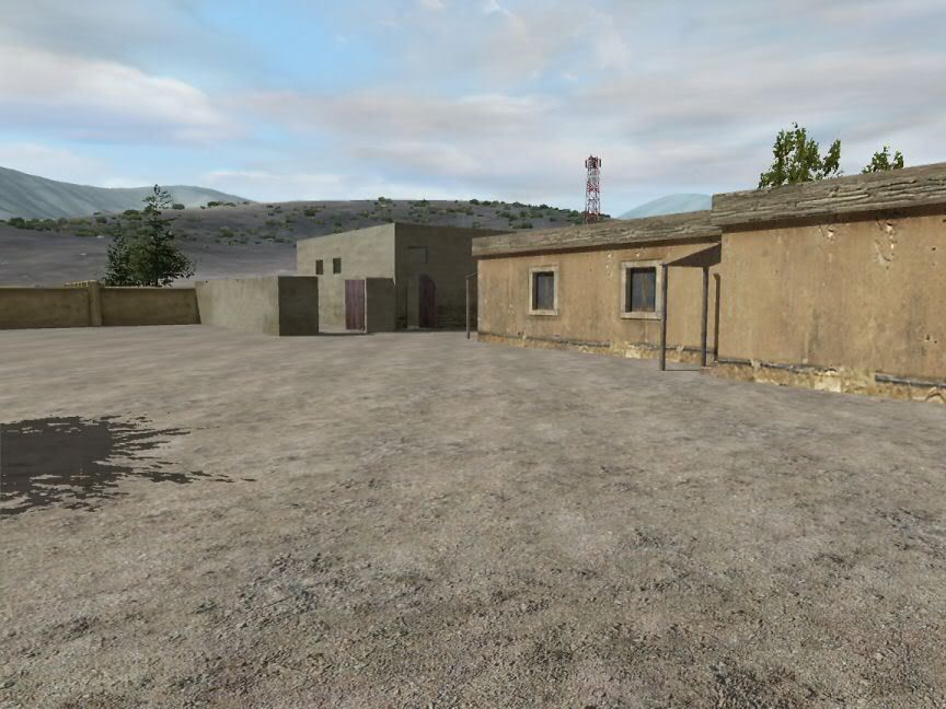
Got to laugh, it's pretty apparent that one's wealth is displayed by the wall height of your Kot (up to 7 meters) and the number and height of your towers. Â The old "keeping up with the Jones' comes to mind, too
 The poor guys in the back country only have low walls and no towers.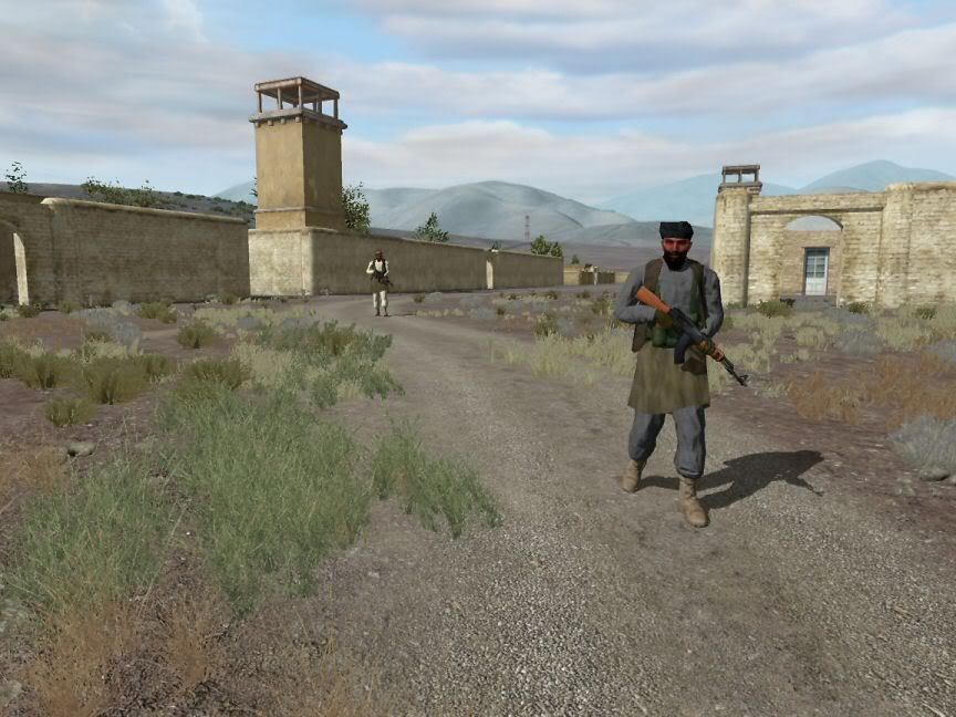
-
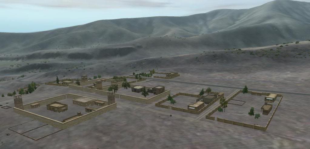
I'm about to the point of an initial release - thanks to Opteryx who is being very gracious in allowing me to use his excellent models. Â In fact, I'd say he's used some of his valuable time to make structures which fit this map. Â Don't know how to thank him enough.
Anyway, this is and still will be very much a work-in-progress. Â There will be:
NO airfield
NO Caves
NO FOBs
So when the time comes, there's no need to waste time or bandwidth if these are important to you.
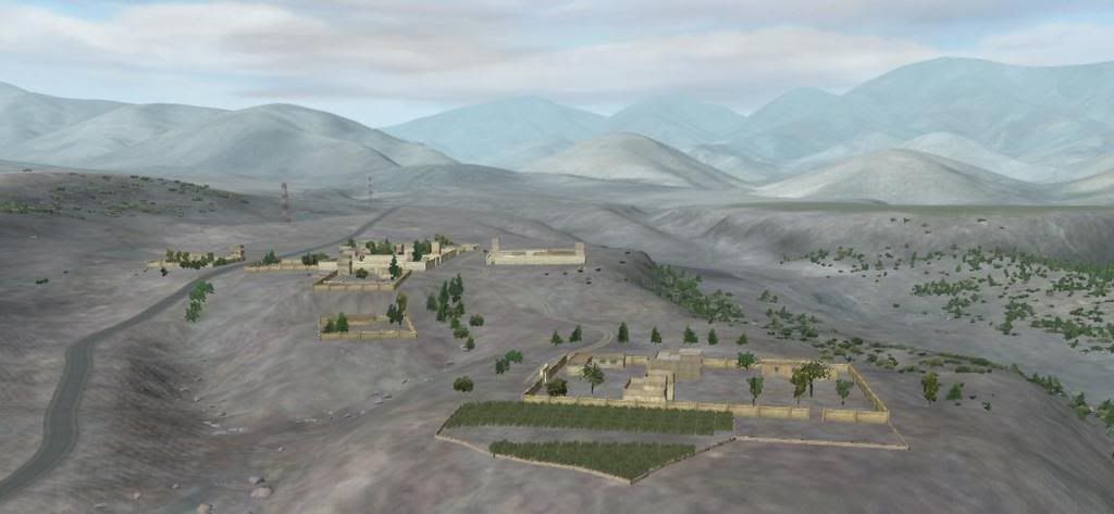
There some Pashtun Kots (usually translated to "compounds") - and there will be MANY more of them all over the map. Some clustered in groups. Â Others scattered around on hilltops and secluded valleys. Â All based on my best analysis of Google Earth to reproduce what is actually there. Â But for now you'll have to settle for what is done. Â Doing my best to have something out by early next month. Â In the meantime, here are some views of recent work:
-
Thanks, BB. The O2 Biki does it's normal crap job of explaining the purpose/need for naming the vertices.
-
Do you have clutter assigned to that texture?
-
Your class stage 2 appears to be the problem. Â I think it needs to refer to a specular map or a specific color - at least that is how most of the BIS model rvmats read. Â Check out an rvmat of an existing wall.
-
Could you give me a clue as to where? Searching for "path" "LOD" etc brings up a lot without helping. Thanks.
-
Examining the Paths LOD in BIS models I notice that vertices are named either IN# or POS#, which reflect the initial point(s) of a path and positions along the path.
How does one create these names/properties when creating a Path LODs?
Thanks.
-
I've not ever seen the program mix terrain types. Â I have experienced the program replacing an undefined or extra color with what it thinks is the closest match. Â This has occurred when I mistaken had more than 4 colors in a segment, or had anti-aliasing on like you described (which obviously creates more than 4 colors per segment).
-
Thanks much! Â Just what I needed. Â Very nice units - they look terrific in the mountains of my Razani map
 (getting close to an initial release)
Schmalfelden Visitor Source Files Posted
in ARMA : MAP EDITING (VISITOR)
Posted
This error message is because you are selecting roads which are not supported in V3. Â These are okay to use:
<table border="0" align="center" width="95%" cellpadding="0" cellspacing="0"><tr><td>Code Sample </td></tr><tr><td id="CODE">
asf10 100.p3d
asf10 25.p3d
asf10 50.p3d
asf10 75.p3d
asf12.p3d
asf25.p3d
asf6.p3d
asf6konec.p3d
asf6_prechod.p3d
ces10 100.p3d
ces10 25.p3d
ces10 50.p3d
ces10 75.p3d
ces12.p3d
ces25.p3d
ces6.p3d
ces6konec.p3d
ces_d10 100.p3d
ces_d10 25.p3d
ces_d10 50.p3d
ces_d10 75.p3d
ces_d12.p3d
ces_d25.p3d
ces_d6.p3d
ces_d6konec.p3d
kos10 100.p3d
kos10 25.p3d
kos10 50.p3d
kos10 75.p3d
kos12.p3d
kos25.p3d
kos6.p3d
kos6konec.p3d
kr_asfaltka_asfaltka_t.p3d
kr_asfaltka_cesta_t.p3d
kr_asfaltka_sil_t.p3d
kr_new_asf_asf_t.p3d
kr_new_asf_ces_t.p3d
kr_new_asf_sil_t.p3d
kr_new_kos.p3d
kr_new_kos_kos_t.p3d
kr_new_kos_sil_t.p3d
kr_new_silxsil.p3d
kr_new_sil_asf_t.p3d
kr_new_sil_ces_t.p3d
kr_new_sil_kos_t.p3d
kr_new_sil_sil_t.p3d
kr_new_sil_sil_t_test.p3d
kr_silnicexsilnice.p3d
kr_silnice_asfaltka_t.p3d
kr_silnice_cesta_t.p3d
kr_silnice_silnice_t.p3d
sil10 100.p3d
sil10 25.p3d
sil10 50.p3d
sil10 75.p3d
sil12.p3d
sil25.p3d
sil6.p3d
sil6konec.p3d
sil6_prechod.p3d
Silnice_mesto_6.p3d
Silnice_mesto_LP_6.p3d
Silnice_mesto_predX_6.p3d
Silnice_mesto_T_12.p3d
Silnice_mesto_X_12.p3d
Silnice_mesto_zJZ.p3d
Silnice_mesto_zVS.p3d
Silnice_mesto_zZJ.p3d
Silnice_mesto_zZS.p3d
You can get the unbinarized MLODs of the other roads by downloading the ARMA_SampleModelsEnvironmentOther pack and build your own rvmats to make them work.