RhodesianScout 189 Posted October 17, 2015 9:30 am Sunday and I have been working almost 12 hours straight on the map. Now I start on the mask which will be used to create the detail texture for the map. This involves covering the whole texture map in green in a layer called dry grass....it would be so simple to leave this as the mask for the map but then the map would kind of look boring with just dry grass blowing in the wind wherever you went in the map. So the next step is to create the granite kopjes, or hills , and add these as another layer specifically showing only the granite kopjes.This involves zooming in to the satellite map and covering each kopje in grey . This could take a while as there are just so many kopjes in this area and I have over 10400 km to cover. The picture below shows some of the kopjes already covered in grey. If you look in the middle of the picture you will see what appears to be a lake with 2 kopjes on either side of it. That should epic in the map. There are between 10 and 20 small roads going through the 10400 km of map and many of these roads wind there way through between small spaces between kopjes. To place these roads after the kopjes are done I will create another layer just for roads and on the texture map draw in all the roads. The roads are small and one lane in each direction with grass or dirt on the edges. When the road layer is completed this will go over the kopjes layer cutting the roads nicely between the kopjes. I also need to check with my map how many different textures I can use in each sector. I believe it is 4 but some times can be 6 different textures. In the picture there are 7 bodies of water...... 5 of them so small they are probably just water holes. These will be added to the mask after the roads. Share this post Link to post Share on other sites
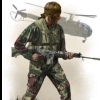
RhodesianScout 189 Posted October 18, 2015 Preview of initial testing. I create the character and export it in fbx format as a low poly model complete with uniform at which stage I can re texture the uniform once added into my modelling program. Next step is to look at how Arma 3 will handle this. Rhodesian Infantry will be shown in the next post 1 Share this post Link to post Share on other sites
RhodesianScout 189 Posted October 18, 2015 Some of the characters for the Rhodesian Light Infantry........ Uniform still to be retextured with Rhodesian Camouflage 1 Share this post Link to post Share on other sites
Crierd 24 Posted October 18, 2015 Hah, these are cool. Where did you get the models or did you make them? 1 Share this post Link to post Share on other sites
RhodesianScout 189 Posted October 18, 2015 And finally for the day this is a preview of what some of the civilians will look like in the Rhodesia Bushwars mod........ my apologies for all the posts in the last 24 hours but a lot of work has been done in that time that I wanted to announce here. Civilians will be seen hiking in the bush , walking along the roads, camping by the lakes or rivers with their tents or any one one of a number of places. In an earlier post I had mentioned that there was a lack of women available , and as long as Arma 3 accepts these models in the end, women will be appearing in the mod alongside the men. Women served in the Rhodesian army and though officially in non-combatant roles they were seen on the front line in roles such as mechanics or with duties and qualifications such as locating land mines. They will appear in the mod as well.... did I just hear the Arma 3 women players just let out a cheer? :) Of course even after getting them into Arma 3 there is still a lot of work to be done as I will need to work out how to animate them in Arma 3. Will some of the black civilians try to pick up an AK47 or will they run away when a fire fight starts. It would not be realistic if the civilians are just standing there when bullets are flying around in the air...... Towards the end of the mod development I will create clothing that was a part of the 60s and 70s. This picture shows the civilians that will appear in the mod.... Arma 3 permitting of course. Share this post Link to post Share on other sites
RhodesianScout 189 Posted October 18, 2015 Hah, these are cool. Where did you get the models or did you make them? These are from a tool by 3ds Max's Autodesk http://www.autodesk.com/education/free-software/character-generator which allows me to customize the characters and then add them into Maya, Unity or 3d Studio. You have to make these characters yourself or the tool prevents you from saving the file . The uniforms and further customization will need to be done in Max., Maya or Unity. 1 Share this post Link to post Share on other sites
RhodesianScout 189 Posted October 18, 2015 My research shows that these characters will indeed work in Arma 3. This picture was submitted last year by member zeealex using exactly the same tool. So my challenge will be to create the same quality as below though I suspect this level of detail requires maximum display settings. Note that the character shown below is similar to the character of the first civilian from the left in my previous post. Share this post Link to post Share on other sites
stephsen 79 Posted October 18, 2015 nice progress mate, thumbs up ! Share this post Link to post Share on other sites
RhodesianScout 189 Posted October 18, 2015 Today I have to do some rethinking on creating the mask........ The first picture shows a kopje......... there is dry grass and trees right up to where the granite kopje climbs up out of the grass. In order for the kopje to exist in the map each one needs to be created with elevation.... I can do this in L3DT. Then to give the kopjes their detailed granite texture I need to create a mask exactly where the edge of the kopje is.....if I am not exact then the grass texture is on the kopje, and vice versa, and that is not what I want. The 2nd picture shows the satellite image on the left and the sample of the mask on the right with one kopje covered in grey....where the granite texture needs to be. If I can not find a solution I may have to cover up issues with the texture with trees, bushes etc...but I do not want to create objects to simply cover up a texture issue. There are roughly 100 to 150 kopjes that need to be textured like this in the map. This is how each kopje needs to look in the map This is an example of the creating the mask for one kopje. Mask needs to be exactly placed where the kopje rises from the ground. 2 Share this post Link to post Share on other sites
RhodesianScout 189 Posted October 19, 2015 This afternoons test in L3DT Pro..... creating a kopje from a satellite image The kopje in this picture is about 100 metres tall. For each kopje I can set the height using elevation data from Google Earth Plus and check the gradient to make sure it is not too steep that a soldier can not climb to the top. I am going to try and make sure that all of the kopjes can be climbed but some of them may be too steep...as is the case in real life. If you look at the picture of the real kopje in my last post you will see that you have no chance of climbing up the side or the right of the kopje but the left side of the kopje has a gradient that will allow you to climb it. This is how I will solve the issue I spoke about in the last post. 1. Set height of kopje I am working on. 2. add texture to the kopje 3. Add dry grass texture to base of kopjeat ground level. After painting the rock and grass textures in L3DT Pro I checked the attributes map and the rock texture and grass texture appeared on the attributes map in the correct spot. Doing these 3 steps in 3d mode in L3DT Pro using Sapphire will give me the detailed precision I need to have granite texture starting at the foot of the kopje as well as having the kopje elevation rising in the same spot as shown on the texture map, the height map and the attributes map. So once done I can then use the attributes map as the mask and use it to add detailed texture maps to the kopjes and surrounding base. Just a note here ...... I remember that not all kopjes were easy to climb and some of them were too steep to climb at all....unless you were a baboon. With the Rhodesia Bush Wars mod with some of these kopjes you will have to try and work out how to get up to the top of the kopje and it will not be a simple matter of running up the slope in the fraction of a few minutes...you may need to spend more time getting up to the top. 1 Share this post Link to post Share on other sites
RhodesianScout 189 Posted October 19, 2015 Early Tuesday morning and a Rhodesian Infantry patrol leaves Maleme (Ma-lee-mee) Dam heading towards Toghwana Dam. This patrol is on a long hike with Toghwana Dam being 18km due east of Maleme. The patrol heads along a deserted road which twists around the granite outcrops. It is a dry and humid summer day and the Tsetse flies are buzzing around the soldiers faces as they march down the road, their combat boots kicking up a trail of dust behind them. The patrol leader stops, signalling his men to a halt as his eyes scan the road up ahead. Just as he spots the face of a ZAPU scout hiding in the fork of a tree up ahead, a whistling sound fills the air. He yells out for everyone to take cover as the mortar shell lands just ahead of them and an explosion rips soil and stones from the road throwing a cloud of dust into the air. The picture below shows Toghwana Dam which is located in the eastern zones of the map and hopefully you can see in the picture that the kopjes are perfectly lined up with the height map that I am using for the terrain. I am still fine tuning the horizontal and vertical scales of the map to get the height of the kopjes correct but it is almost there. Once that is done I can then create the mask using the procedure from the last post. I will still need to sculpture the kopjes and texture them as previously mentioned which then updates the attributes map and hence will give me a mask for the map. At 3 o'clock this morning when I did a 3d preview of the map I saw the Toghwana Dam sitting on the floor of the valley and each kopje I checked rising from the ground as it should be....... very good signs for this project. 1 Share this post Link to post Share on other sites
jimbop 25 Posted October 19, 2015 you wanna scrap this map and write a novel instead!! lol I bet you have 1000 mission ideas buzzing in your head. :) 1 Share this post Link to post Share on other sites
RhodesianScout 189 Posted October 19, 2015 Started work this morning on adding the hills, or kopjes, to the map. Even though the height map is now greatly improved giving the map a more realistic representation of this area of Rhodesia, the height map alone cannot do justice to the kopjes. Each one needs to be added by hand. So the picture below shows the 2nd kopje I have created for the map and I believe I have roughly between 100 and 150 of them to do for the entire map. So I have set a target for how many I will do every day and with luck that part of the project will be finished in 3 weeks or more. The southern part of this map is fairly flat with the occasional kopje, as seen in the picture below....but as the picture shows if you look towards the north of the map the terrain becomes a lot more challenging even for the seriously fit soldier as not only are there huge hills and granite boulders to walk around or over but there is heavy bush making trekking through them very hard. And being Africa there are other things in the area to avoid........ < a teaser of what is coming to the map > Oh...and to show the size of this small part of my overall map....I have highlighted a soldier with the black arrow just so you can see the size comparison. Share this post Link to post Share on other sites
serjames 357 Posted October 19, 2015 jeez... the scale is huge... You've definitely taken a huge mouthful there :-) Would love to see a southern africa map so really got my fingers and toes crossed for this ! 1 Share this post Link to post Share on other sites
RhodesianScout 189 Posted October 20, 2015 I have to revise what I said 90 minutes ago... in that time I have created another 5 kopjes in the map so on any good day I should be able to do 20 to 30 of them........so still looking at a few weeks but not months. Share this post Link to post Share on other sites
RhodesianScout 189 Posted October 20, 2015 jeez... the scale is huge... You've definitely taken a huge mouthful there :-) Would love to see a southern africa map so really got my fingers and toes crossed for this ! Yes..... it makes me wonder what I have got myself into. Not all of the kopjes are this size ..... a lot of them are much smaller and much easier to get your troops across. The picture below is an example of a massive kopje that illustrates the scale some of them get to. Just imagine in 10 years time when I have finally finished this mod (joking...I will easily finish in 8..... another joke :) ) and you are driving in a convoy down this road as shown below with the Toyota and suddenly you take sniper or AK fire coming from somewhere on that huge kopje. You know you are going to have to go up there and sort those guys out....how you do that is a good question you will have to solve. With the picture below you would say there would be no way the sniper is on the top of that boulder on the left....unless there is an easier way up at the back....looks can be deceiving. This brings up a question.......... when is a kopje not a boulder not a hill...all 3 are in the map with the smaller boulders all around the map with the kopjes and the much larger hills being found in the north. Share this post Link to post Share on other sites
khan_artist 16 Posted October 20, 2015 excited to see this come to fruition. keep it up bro. we need more worldy conflicts in this game. 1 Share this post Link to post Share on other sites
RhodesianScout 189 Posted October 20, 2015 Two weeks ago I had announced that one of the projects I had being working on for the mod was the Garret steam locomotive. Since then the Rhodesia Bush Wars map has expanded considerably in a different direction and while this means that the Garret locomotive may still be done it's priority has moved down the ranks somewhat for something that will have more priority. What has taken it's place in priority is going to be announced later this week on this mods youtube channel....... but if you want a hint just look at the picture below for an early preview. Share this post Link to post Share on other sites
RhodesianScout 189 Posted October 21, 2015 The mask will be completed tomorrow well ahead of time which means the map will be generated either late tomorrow night or Friday. The picture below gives the first look at how rugged the terrain will be . Top and bottom sectors of the map will be fairly easy but the middle section will be a challenge with long tall hills, thick bush and winding ravines. You can see spread across the map all the hills, kopjes and boulders I have to add to the map. One of the missions will have ZAPU or ZANU forces patrolling in random areas around the map....you will not know where they are and you will have to do a patrol either by road or on foot to try and locate them. The mission will have the increased difficulty in that land mines will also be randomly placed and you may or may not come across them. Other missions will have you being sent to specific hot spots on the map where terrorists have been spotted or civilians attacked. You may arrive by the shores of a lake and see empty tents and then have to try and find where the enemy has gone and rescue the civilians. The map consists of 10,404 km of African bush, sparse in some places but thick in others. If your path is blocked by thick vegetation or fallen boulders you may need to climb over kopjes to continue your patrol. Some of the kopjes will be easy to climb...others will be hard and will leave you breathless after the climb. Then you will have to try and find your way down the other side. Most maps for Arma 3 have towns or villages that you can wander through........ With this map you are in the African bush and you would need to travel 10 km or so north of this maps most northern edge to reach Bulawayo. There will be a few park buildings spread around the map but this map focuses specifically on you, the enemy and the bush. There are plenty of roads throughout the map but you will need to be wary of landmines planted anywhere and the risk of snipers firing on you or the road being hit by mortar fire. 1 Share this post Link to post Share on other sites
Cype_Revenge 651 Posted October 21, 2015 I came across this mod in progress today [WIP] Terrain Diyala province Iraq https://forums.bistudio.com/topic/182805-wip-terrain-diyala-province-iraq/ Am doing some testing to see if I can get my map to look anything close to what this guy has done. Will answer your question when I have finalized terrain resolution Edit: I had a look at The Lost Island map created by the same guy developing Diyala Province. Lost Island looks great but with 220,000 objects around the 10km island I had to lower my graphics settings. I am going to try and give my mod the atmosphere and appearance of Africa so you will feel like you are there...... and still play if your computer is not up to specs......... I have put together 10 different sound files in ogg format and have around 150 more sound files to do........sound will play a big part in making this mod believable. i missed this post..... :) Lost Island is all created on L3DT, with a Satmap painted on Photoshop. That was my first project. Diyala is completely different, Highresolution Satimage and a real Terrain Highmap. If you any questions you can pm me Share this post Link to post Share on other sites
serjames 357 Posted October 21, 2015 Loving the Alouette ! Share this post Link to post Share on other sites
McLupo 118 Posted October 22, 2015 Hi, since you started your huge project, it is fantastic to read your progress and the enthusiasm with which the work will be created. :) Keep it up. Greetings McLupo 1 Share this post Link to post Share on other sites
RhodesianScout 189 Posted October 22, 2015 Still working on the terrain map...... as well as editing the first youtube video which is hopefully released on the weekend. When I am taking a break from the above I am doing research and collecting material for the mod One of the first couple of armored vehicles I am creating for the Rhodesia Bush Wars is the Rhino......a Land Rover based patrol vehicles with a shaped body to deflect the blast wave from landmines....... a V-bottomed crew cab sitting above the Land-Rover chassis and pretty effective against land mines. This is an essential vehicle that needs to be added to the mod...... thus it is in my development queue. Share this post Link to post Share on other sites
Foxone 1044 Posted October 22, 2015 Still working on the terrain map...... as well as editing the first youtube video which is hopefully released on the weekend. When I am taking a break from the above I am doing research and collecting material for the mod One of the first couple of armored vehicles I am creating for the Rhodesia Bush Wars is the Rhino......a Land Rover based patrol vehicles with a shaped body to deflect the blast wave from landmines....... a V-bottomed crew cab sitting above the Land-Rover chassis and pretty effective against land mines. This is an essential vehicle that needs to be added to the mod...... thus it is in my development queue. That is one sexy looking vehicle, i want it IRL! LOL Share this post Link to post Share on other sites